Impacsts of cc on catment flow and asses its impacts onhydropower in VN central highland region
Bạn đang xem bản rút gọn của tài liệu. Xem và tải ngay bản đầy đủ của tài liệu tại đây (593.33 KB, 8 trang )
Global Perspectives on Geography (GPG) Volume 1 Issue 1, February 2013
www.as-se.org/gpg
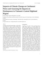
Impacts of Climate Change on Catchment
Flows and Assessing Its Impacts on
Hydropower in Vietnam’s Central Highland
Region
Ho Quoc Bang1*, Nguyen Hong Quan1, Vo Le Phu2
*Institute for Environment and Resources (IER), VNU-HCM, Vietnam, 142 To Hien Thanh st., Dist.10, HoChiMinh,
Vietnam
1
Ho Chi Minh City University of Technology / VNU-HCM, 268 Ly Thuong Kiet St., Dist. 10, Ho Chi Minh City,
Vietnam
2
1*
, 1 ;
Abstract
According to the Fourth Assessment Report – AR4 in 2007 of
the Intergovernmental Panel on Climate Change (IPCC),
climate change is a complex problem and becoming the
leading challenge for humankind in the 21st century. Therefore,
assessing climate change impacts on the social, economic
activities and proposed solutions to respond to climate change
is urgent and necessary. This study applied the GIS
(Geographic Information System) technique and SWAT model
(Soil and Water Assessment Tool) to simulate water flows due
to the impact of climate change. The models were applied for
several catchments in and around Dak Nong province. The
results of catchment flows can be useful information for many
purposes, such as: flood forecasting, predicting sediment loads
and impact assessment of climate change on water resource
and hydropower. In this study, the issues of hydropower
safety and electricity generation capacity in Dak Nong up the
year of 2020 are focused. The results of SWAT model show
some certain changes in catchment flows due to climate
change, for example, the maximum streamflow in the upper
part of Serepok River in 2020 is higher than that in the period
of 2005 to 2010 about 16.8%. The results also showed that the
hydropower dams’ safety in Dak Nong province is secured
given the climate change scenarios. In addition, given the
changes in catchment flows due to climate change , the
hydroelectric ouput of Dak Nong in 2020 are only 7,063 million
kWh/year, which is less than about 12% in comparison to the
expected production.
Keywords
Climate Change; Swat Model; GIS; Hydropower; Vietnam
Introduction
According to the IPCC’s Fourth Assessment Report
(AR4), climate change is a complex problem and
becoming the leading challenge for humankind in the
21st century (IPCC, 2007). Many studies showed that
climate change is mainly caused by the emission of
greenhouse gases (mainly CO 2 and CH 4 ). Especially
since 1950, the rapid growth of urbanization and
industrialization had led to an acceleration of human
consumption and an increase in emissions. One of the
biggest industries greenhouse gas emissions is electricity
production which occupies about 50% of global CO 2
emissions (Lansiti, 1989). Because electrical industry
emits a large amount of greenhouse gases, therefore the
energy sector has to cut greenhouse gas emissions for
mitigation of climate change. Many solutions have been
given to the energy sector, such as: using other fuels
producing less CO 2 , using modern energy efficient
alternatives or increasing use of renewable energy
sources. Among the alternative power production in
thermal power, hydropower is an attractive option
because hydropower is a form of renewable energy, less
greenhouse gas emissions and hydropower infrastructures have a long lifetime. Therefore, in recently years,
although the construction of large-scale hydropower
dams have made locals emigrate and caused ecological
impacts on the basin, governments in most countries
have still continued to construct more hydropower
plants because of its important role played in the econo-
1
www.as-se.org/gpg
Global Perspectives on Geography (GPG) Volume 1 Issue 1, February 2013
FIG. 1 LOCATION OF DAKNONG PROVINCE IN VIETNAM (LEFT) AND ITS TOPOGRAPHY (RIGHT)
mic development, especially in developing countries
and less developing countries.
12o50’ northern latitude and 107o13’ - 108o10’ eastern
longitude.
It is estimated that there will have 69 hydropower
projects in Dak Nong province, Viet Nam by 2015.
According to the Dak Nong industry and trade
department, 37 hydroelectric projects (including 25
small-scale and 12 large-scale hydropower facilities)
have been investing and operating in 2010 with a total
capacity of 1905.96 MW. However, the massive
hydroelectric development in recent years can be
affected by climate change in the future. The change of
water flow is likely one of the potential impacts in the
age of human-induced climate change. Hence, for ease
on the impact of climate change on hydropower
systems in Dak Nong, this paper presents an
application of GIS (Geographic Information System)
and SWAT (Soil and Water Assessment Tool) model to
simulate water flows, then results of the model are
used for assessing climate change impacts on
hydropower in Dak Nong province.
The province’s climate condition is influenced by
the climate of eastern and western of Truong Son moutain
Study location, data and methods
Study Location
Dak Nong is located in the southern part of Vietnam’s
Central Highland region (FIG. 1). Dak Nong borders
with Dak Lak in the north, Lam Dong in the southeast, Binh Phuoc and Cambodia in the west. Its
elevation is about 500m above sea level. The terrain is
lower in the west. Dak Nong coordinates at 11o45’ -
2
range. It is characterized by less directly affected by
storm, high temperatures and solar radiations. The ave-
rage annual temperature is about 21 - 24oC. Total
yearly hours reach 2,200 - 2,400 hours/year. Total amount
of
radiation
is
233
240 Kcalo/cm2. Annual evaporation, relative humidity
and rainfall are abour 1,000 - 1,400 mm, 81 - 85%
and 1,600 - 2,500 mm respectively (Nguyen and Ho.,
2011).
Dak Nong has two main river basins, including Serepok and DongNai rivers. Almost area of the province is
in the Serepok river basin and the remain-ing part
is the DongNai river basin. The Serepok river has two
major tributaries which are KrongNo and KrongAna
rivers. The total area of KrongNo river basin
is 4,620 km2 and the main stream is 56 km in
length. KrongAna river has a total river basin is
3,200 km2, and the legnth of the main river section is 215
km. The DongNai river basin covers an area of approxi
mately 2,526 km2 (Ngu-yen and Ho., 2011). The stream
nerwork in the provin-ce is quite complex, thick
and many small tributaries. These are favorable
conditions to exploit water resour-ces for agricultural
Global Perspectives on Geography (GPG) Volume 1 Issue 1, February 2013
practices, hydropower pro-duction and domestic uses.
Data Collection
Collected data in the catchments are meteorological
and hydrological data in many stations in and around
Dak Nong (including Cau14 station, GiangSon station,
DakMil station, DucXuyen station and Dak Nong station). The collected data are (1) daily evaporation; (2)
hourly rainfall; (3) wind direction and speed; (4) hourly
temperature; (5) hourly humidity and (6) hourly streamflow.
Land use map is provided by the Dak Nong Department of Natural Resources and Environment, while the
topographic map is collected at the Vietnam National
Information and Communication Technology Department at 1:25.0000 Scale, which can be used later for
generating a Digital Elevation Model (DEM). Climate
change variations are up the year of 2030, including
temperature, rainfall, and evaporation from the Vietnam Institute for Meteorology, Hydrology and Environment (IMHEN, 2007).
www.as-se.org/gpg
(EPIC) (Williams et al., 1984). Many docu-mented
applications of SWAT model for assessing water
resources have are Van Liew and Garbrecht (Van et
al., 2003) using the SWAT model to predict streamflow under varying climatic con-ditions for
three nested watersheds in Little Washita River
Experimental Watershed in Okla-homa. Chu and
Shirmohammadi (2004) (Chu et al, 2004) applying
SWAT model for the calculation of surface flow for
a small watershed in Maryland. Spruill and others
(Spruill et al., 2000) using SWAT model to determine
daily streamflow for a small karst-influenced
watershed in central Kentucky during the period of
2 years, etc.
2)
SWAT’s application in Dak Nong province
Methods
1)
SWAT model
The SWAT model was developed in the early 1990’s
by the U.S. Department of Agriculture, Agricultural
Research Service (USDA–ARS) (Arnold et al., 1998).
The model was developed to assess and predict the
impact of land management affect on water, sludge,
and the amount of chemicals used in agricultural
practices on a large and complex basin with
unstable factors of soil, landuse and management
conditions in a long time. The model includes a set
of regression calculations to describe the relationship between the input and output parameters. The
SWAT model integrates many different models of
ARS, which are developed from model for Simulator for Water Resources in Rural basins (SWRRB)
(Williams et al., 1985; Arnold et al., 1990). Specific
models that contributed significantly to the
development of SWAT model were: (i) Chemicals,
Runoff, and Erosion from Agricultural Management Systems (CREAMS ) (Knisel, 1980); (ii) Groundwater Loading Effects on Agricultural Management Systems (GLEAMS ) (Leonard et al., 1987);
(iii) and Erosion-Productivity Impact Calcu-lator
FIG. 2 DESCRIBES THE APPLICATION PROCEDURE OF
SWAT IN DAKNONG, VIETNAM
3
www.as-se.org/gpg
3)
Global Perspectives on Geography (GPG) Volume 1 Issue 1, February 2013
Model calibration and validation
The SWAT model was calibrated by using SWATCUP software. Several statistical approaches can be
used to check SWAT model performance such as:
coefficient of determination (R2), Nash-Suttcliffe
Simulation Efficiency (NSE) (Nash and Suttcliffe,
1970), mean absolute error (MAE), Root Mean
Square Error (RMSE), and Theil’s inequality coefficient (U).
+ Nash-Suttcliffe Simulation Efficiency (NSE).
0.89, 0.84 for Dak Nong station, DucXuyen station
and Cau14 station, respectively. These NSE values
are almost higher than 0.7, therefore the model and
the parameters can be used to simulate catchment
flows in the province under climate change scenarios.
Results and discussions
Results of streamflow
The continous of monthly streamflow at the Cau 14
station and some statistical numbers of streamflow of
four catchments in Dak Nong province are shown in
FIG. 4 and TABLE 1.
Where: P is simulation values ; O is measurement
values and N is the number of monitors.
+ SWAT-CUP is a computer program for calibration
of SWAT models. The program links GLUE, ParaSol,
SUFI2, MCMC, and PSO procedures to SWAT. It
enables sensitivity analysis, calibration, validation,
and uncertainty analysis of a SWAT model. The
program structure approach is as shown in the FIG.
3.
FIG. 4 PREDICTED DAILY STREAMFLOW IN 2030 AT CAU 14
STATION, DAKNONG
FIG. 3 SWAT-CUP APPROACH
In this paper, the Nash-Suttcliffe simulation
efficiency was used. The statistic results of the
average NSE between simulations and measurements for model calibration and validation are 0.86,
4
FIG. 5 PREDICTED MONTHLY STREAMFLOW IN 4 PERIODS AT
CAU 14 STATION, DAKNONG
Global Perspectives on Geography (GPG) Volume 1 Issue 1, February 2013
FIG. 6 PREDICTED YEARLY STREAMFLOW IN 4 PERIODS AT CAU
14 STATION, DAKNONG
TABLE 1 STREAMFLOW IN 2005-2010, 2015 AND 2020 AT 4
CATCHMENTS (M3/S)
Serepok
Krong
No
DongNai’s
main stream
Dak Nong
station
Maximum
2210
1290
2600
147
Average
272
87.4
1110
18.2
Minimum
16.4
0.9
215
1.3
Maximum
1789.7
1263.5
1647.7
93.2
Average
220.3
85.6
703.4
11.5
Minimum
13.3
0.9
136.3
0.8
2120.8
1507.2
2050.7
115.9
Average
261
102.2
875.5
14.4
Minimum
15.7
1.1
169.6
1
Streamflow
2005-2010
2015
2020
Maximum
Assessing Climate Change Impacts on Hydropower
1)
Climate change impacts on hydropower safety
Climate change likely leads to increased intensity of
floods and the flood peak. In some extreme cases,
www.as-se.org/gpg
the hydropower plant has to discharge to ensure
the safety of hydropower dams in the flood season.
Streamflows and flash flood levels are the parameters used to assess the impact of climate change
on the safety of hydropowers (Thang et al., 2010).
Thus, the changes of streamflows due to climate
change from SWAT model simulations and the
design flash flood flows of each hydropower
(TABLE 2) are used to assess the impact climate
change on the hydropower safety. The results show
that the design flash flood flows of 37 hydropowers
in Dak Nong are higher than the maximum level of
streamflows in Dak Nong’s catchments, although
the maximum level of streamflows in some river of
Dak Nong’s catchements in 2020 are higher that in
the period of 2005 to 2010. Such as the maximum
level of streamflows in Krong No river is 1507.2
m3/s in 2020, while the maximum level of
streamflows in the period of 2005 to 2010 is only
1290.0 m3/s (TABLE 1). Therefore, the hydropower
dams’ safety in the province is secured given the
climate change scenarios.
2)
Climate change assessment impacts on
electricity generation capacity
Climate change refers to any significant change in
climate factors, including precipiration, temperature, storm patterns and intensity, etc. The decrease
of precipitation or increase of temperature will
likely result in drought events. Drought and reducing streamflow lead to the reduction of hydropower supply (Cherry et al., 2010). Therefore, the
change of streamflows from SWAT model simulations due to climate change and the expected streamflows for generating maximum electicity are used to assess the impact of climate change on electricity generation capacity in Dak Nong pro-vince
(TABLE 2). The results showed that the hydroelectric output in 2010 is about 5,450 million kWh/year. It is expected that the hydropowers are not affected by reduced streamflow due to climate change,
and in 2020 the hydroelectric output will reach
to 8,072 million kWh/year. However, the
hydroelectric ouput of Dak Nong in 2020 is
only 7,063 million kWh/year. However, production
tends to decrease as it is less than about 12%
in comparison with the proposed production due to
the impact of human-induced climate change.
5
www.as-se.org/gpg
Global Perspectives on Geography (GPG) Volume 1 Issue 1, February 2013
TABLE 2 TECHNICAL SPECIFICATIONS OF HYDROPOWERS IN DAKNONG
Hydropower
name
River Basin
Q design flash
flood flow (m3/s)
Material
of dams
Q generated max
electricity(m3/s)
Annual electricity
generated (106 kWh)
Dak Buk Sor 1
Dak Sin
Dak Kar
DongNai
DongNai
DongNai
746.02
552
683
7.82
12.31
5.72
11.76
105.18
30.52
Dak R’Keh
Dak A.Kong
Dak Ru
Quảng Tin
DongNai
DongNai
DongNai
DongNai
331.5
242.8
758
460
6.85
4.3
10.3
6.7
11.09
7.46
29.8
20.3
Dak Glun 2
Dak Glun 3
Dak Sor 1
Dak Sor 2
DongNai
DongNai
Serepok
Serepok
394.03
458.6
645
590.7
5.8
8.75
5.9
9.74
13.73
25.63
18.326
22.64
Dak Sor 4
Serepok
721
Soil dam
Soil dam
Soil dam
Beton
dam
Soil dam
Soil dam
Soil dam
Beton
dam
Soil dam
Soil dam
Soil dam
Beton
dam
17.62
27.6
7.53
14.9
13.2
8.36
11.57
5.45
7.82
-
42.33
26.321
31.8
52.8
5.995
19.05
11.76
64.09
8.01
7.21
19.37
8.71
58.688
25.51
2.04
9.55
507.42
316
336.36
1458
204.9
358.6
412.8
-
1060.2
118.4
215
607.1
50/67
636.8
221
1109.5
298
-
604.43
929.16
37
-
132.5
Da Klong
Dak Rung 1
Dak Rung
Dak N’Teng
Nhan Co (ĐR)
Dak Mam 2
Dak Buk Sor 1
Dray H'linh 2
Dak Nong
Dak Nong 1
DongNai
DongNai
DongNai
Serepok
DongNai
Serepok
DongNai
Serepok
DongNai
DongNai
384
525
576
431
384.5
356.3
746.02
-
Dak Nong 2
Dak Nir
DongNai 1
DongNai 1
753
170.5
Dak Muong
DongNai
123
Serepok 4
Buon Kuop
Serepok
Serepok
9592.2
8000
Krông Nô
4267
Buon T. Srah
6
Serepok 3
Day H'linh 1
Serepok
Serepok
8760
-
DongNai 3
DongNai
10400
Dak R’Tih
DongNai
2360
DongNai 4
DongNai
10000
DongNai 5
DongNai 6
Chu P.Prong
DongNai
DongNai
Serepok
8320
-
Hoa Phu
Serepok
-
Beton
dam
Soil dam
Soil dam
Soil dam
Soil dam
Soil dam
Soil dam
Beton
dam
Soil dam
Beton
dam
Beton
dam
Soil dam
Beton
dam
Beton
dam
Beton
dam
Beton
dam
Beton
dam
Beton
dam
Note: “-“: Non-value
Global Perspectives on Geography (GPG) Volume 1 Issue 1, February 2013
Conclusion
The results of SWAT model show some certain changes
of catchment flows due to climate change, for example,
the maximum streamflow in the upper part of the
Serepok river in 2020 is higher than that in the period of
2005 to 2010 about 16.8%. It also shows that the
hydropower dams’ safety in Dak Nong province is
secured given the climate change scenarios. In addition,
given the changes of catchment flows, in 2020 the
hydroelectric output will reach 7,063 million kWh/year(less than about 12% in comparison with the expected
production).
IPCC.,
www.as-se.org/gpg
2007.
Climate
Contribution
Change
2007:
Synthesis
Report.
of Working Group II to the Fourth
Assessment Report of the Intergovernmental Panel on
Climate Change. Cambridge University Press, Cambridge.
Knisel, W. G., 1980. CREAMS: A field scale model for
chemicals,
runoff,
and
erosion
from
agricultural
management systems, U.S. Dept Agric. Conserv. Res.
Report No. 2
Lansiti, E., and Niehaus, F., 1989. Impact of energy production
on atmospheric concentration of greenhouse gases Energy
systems must be restructured to reduce emissions of
REFERENCES
Arnold, J. G., Williams, J. R., Nicks, A. D., and Sammons, N .B.,
1990. SWRRB: A basin scale simulation model for soil and
water resources management, Texas A&M Univ. Press,
College Station, TX.
Arnold, J. G., Srinivasan, R., Muttiah R. S., and Williams, J. R.,
1998. Large area hydrologic modeling and assesement. Part
1: model development. Vol 34, J. Americam Water
Resources Associaton, 73-89
Cherry, J. E., 2010. Impacts of Climate Change and Variability
on Hydropower in Southeast Alaska, Planning for a Robust
Energy Future International Arctic Research Center and
Institute of Northern Engineering at the University of
Alaska Fairbanks. 2010.
Chu, T. W., and Shirmohammadi, A., 2004. Evaluation of the
SWAT model’s hydrology component in the Piedmont
physiographic region of Maryland, Transaction of the
American Society of Agricultural Engineering (ASAE), Vol
47, no. 4, 1057–1073.
Di Luzio, M., Arnold, J.G., and Srinivasan, R., 2004. Integration
of SSURGO maps and soil parameters within a geographic
information system and nonpoint source pollution model
system, Journal of Soil and Water Conservations, Vol 59,
123–133.
IMHEN., 2007. Vietnam Institute for Meteorology, Hydrology
carbon dioxide, IAEA Bulletin, Feb. 1989
Leonard, R. A., W. G. Knisel, and D. A. Still. 1987. GLEAMS:
Groundwater loading effects on agricultural management
systems. Trans. ASAE, Vol 30, no 5, 1403-1428.
Nguyen, N. V., and Ho, Q. B., 2011. Climate change adaptation
plan for Dak Nong province, Vietnam. Dak Nong
Deparment of Natural Resources and Environment and
IER. Technical report 12/2011
Spruill, C. A., Workman, S. R., and Taraba, J. L., 2000. Simulation of daily and monthly stream discharge from small
watersheds using the SWAT model, Trans.ASAE, Vol 43,
no. 6, 1431–1439.
Thang, N. V., 2010. Climate change and its impacts in Vietnam.
Vietnam
Institute
forMeteorology,
Hydrology
and
Environment (IMHEN).
Van Liew, M. W., and Garbrecht, J., 2003. Hydrologic simulation of the Little Washita River experimental watershed
using SWAT, Journal of American Water Resources Association, Vol 39, no. 2, 413–426
Williams, J. R., Jones, C. A., and Dyke, P. T., 1984. A modeling
approach to determining the relationship between erosion
and soil productivity, Trans. ASAE, Vol 27, no 1, 129-144.
Williams, J. R., Nicks, A. D., and Arnold, J. G.,1985. Simulator
for water resources in rural basins, J. Hydrol. Eng., Vol 111,
no 6, 970-986.
and Environment.
7
www.as-se.org/gpg
Global Perspectives on Geography (GPG) Volume 1 Issue 1, February 2013
Bang Q. Ho was born in Vietnam, on
17/12/1979. He got Docteur ès Sciences
(Ph.D.) degree on Environmental Science
(Emission inventories and air quality
modelling) at the Swiss Federal Institute of
Technology in Lausanne (EPFL), Switzerland in 2010. He is doing research on
Climate Change, Energy and Air quality
fields.
He got Master degree on Environmental Science at the Swiss
Federal Institute of Technology in Lausanne (EPFL),
Switzerland in 2005. From 1997 to 2001: he did Bachelor of
Analytical Chemistry at the University Sciences Natural /
Vietnam National University in Ho Chi Minh City. From 2001
to 2011 he has worked for several Labs in IER (System
laboratories lab, Air quality lab), EPFL (LPAS, LASIG) and also
in French National Center for Scientific Research - France on
Emission inventory, Modelling of Meteorology and Air
pollution, monitoring of air quality and water quality, Climate
change. In 2011 he worked at Duke University, USA as visiting
scholars on Energy and Environment. He is doing as a
National Consultant and Regional consultant on Air emission
inventories for ASEAN Ports funded by German Technical
Cooperation (GIZ).
Dr. Ho is currently a Director of Air Pollution and Climate
Change Department/Institute of Environment & Resources
8
(IER)/Vietnam National University, HoChiMinh City (VNU/HCM). He teaches many courses on “Sustainable Energy
Use”, “Climate Change”, “Control of air pollution and noise”
and “environmental modelling” for master and engineer
levels.
Hong Q. Nguyen was born in Vietnam, on
22/12/1979. He got Docteur ès Sciences
(Ph.D.) degree on Environmental Science
Braunschweig Uni-versity of Technology.
He is doing resear-ch on Climate Change,
water management fields.
Dr. Quan is currently a vice director of
natural resources management depart-ment / /Institute of
Environment & Resources (IER)/Vietnam National University,
HoChiMinh City (VNU/HCM).
Le P. Vo was born in Vietnam, on
9/6/1971. He got Docteur ès Sciences
(Ph.D.)
degree
on
Environmental
Science Adelaide, Sou-th Australia,
Australia. He is doing resear-ch on
Climate Change, water management
fields.
Dr. Vo is currently a Vice Dean of Environment Faculty, of University of technique / Vietnam
National University, HoChiMinh.