Tài liệu Understanding the GPS P1 pptx
Bạn đang xem bản rút gọn của tài liệu. Xem và tải ngay bản đầy đủ của tài liệu tại đây (2.15 MB, 40 trang )
Copyright ©1996, Gregory T. French. All rights reserved.
No part of this work may be reproduced in any form, or by any means,
without the permission of the publisher. Exceptions are made for
brief excerpts to be used in published reviews.
Published by
GeoResearch, Inc.
8120 Woodmont Avenue, Suite 300
Bethesda, MD 20814
Library of Congress Catalog Card Number: 9680018
ISBN: 0-9655723-O-7
Printed in the United States of
America
This book is available at quantity discounts for bulk purchases.
Supplemental materials for instructors and trainers are available
in various media.
For information, call 800-GEOLINK or 301-664-8000.
Preface
There is an ever-growing supply of information about the Global
Positioning System. Unfortunately, these new (and now, some not so
new) documents seem to be located at each end of the comprehension
scale: either at the “gee-whiz” level which basically describes how inter-
esting and useful this new utility is, or at the engineer’s level which
starts out with Keplerian orbits and
Hopfield
Modeling. What seems to
be missing is a comprehensive, yet easy to understand, presentation of
the Global Positioning System (GPS) for people who may have a very
real need to apply this new technology but lack the basic understanding
necessary to make important, and often expensive, decisions about it.
Thus this book.
This book is designed to support an introductory course on the
fundamentals of the Global Positioning System based on a series of
graphic representations and distilled concept-bullets. Math is scrupu-
lously avoided-that level of information is readily available through
numerous highly technical publications and is no more necessary for
most users than is a textbook on electronics necessary for the purchaser
of a television set.
Each concept is presented in one to four graphics found in this
book on the
left
page of each page-pair. The opposing right page pres-
ents a brief discussion of the concept. While much more could be said
on each of the topics presented, only those highlights considered by the
author to be of most immediate value to the geographer, project man-
ager, field technician, or others needing to learn the fundamentals of the
GPS are included here. At the end of the book, there is a list of sug-
gested readings for those who are interested in gathering more in-depth
and detailed information on most of the topics covered.
Errata
Page
12. Graphic shows VOR, Transit, ILS, and GPS incorrectly located along the electromagnetic spectrum. This has
been corrected in the presentation packages (overheads and 35mm slides).
Page 83. Paragraph three should read:
Although that is the
theoretical
maximum resolution possible in carrier-phase positioning, modem. geodetic
surveying receivers are regularly achieving testable and repeatable accuracy in the area of one to two
centimeters, or 10 to 20 millimeters, at a 95% probability level. Some claim even higher accuracy.
Page 103. Paragraph two, first sentence should read:
PDOP,
or
Position Dilution of Precision,
probably the most commonly used, is the dilution of precision in
three dimensions.
Page 144, 145. NOAAJCORS has recently changed the web pages to make navigation easier. Therefore, the graphic
and navigation instructions no longer accurately represent the current pages. The address remains the same.
This has been updated in the presentation packages (overheads and 35mm slides).
Page 168. Graphic should read:
THE LATEST AND GREATEST BEST FIT ELLIPSOID IS
The World Geodetic System of 1984
This has been corrected in the presentation packages (overheads and 35mm slides).
Page 169. First sentence, first paragraph should read:
The latest and greatest best-fit ellipsoid is the World Geodetic System of 1984, or WGS84.
Contents
Part I Introduction and Background
Introduction 3
Topics 7
What is GPS? 9
Radio-Navigation Systems 11
Evolution of the GPS 15
GPS Civil Applications 19
GPS Segments 21
Control Segment 23
Control Segment Locations 25
Space Segment 27
Orbits 29
Launch History 31
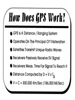
How Does GPS Work?
33
Two-Way vs. One-Way Ranging 35
Single Range to Single Satellite 37
Two Ranges to Two Satellites 39
Three Ranges to Three Satellites 41
Why Four Satellites?
43
Clock Timing Error 45
Part II Basic Signal Structure and Error
Levels of GPS Service 53
Basic Signal Structure 55
Pseudo-Random Codes 59
Where Are the Satellites?
65
GPS Signal Structure Map 67
Signal Strength 69
GPS Resolution
-
C/A-Code 71
GPS Resolution
-
P-Code 73
Anti-Spoofing (A/S) 75
iii
Carrier-Phase Positioning 79
GPS Resolution - Carrier-Phase 83
GPS Velocity 85
GPS Error Budget 87
Ionospheric / Tropospheric Refraction 89
Satellite Mask Angle 91
Multi-Path Errors 93
Selective Availability 95
Dilution of Precision (DOP) 97
Project Planning 105
Position Offsets 109
Almanacs 117
Absolute Accuracy 119
Part III Data Correction Techniques and
High-Resolution Accuracy
Differential Correction 123
Post-Processed Corrections 127
Real-Time Corrections 131
Post-Processing vs. Real-Time 135
Differential Data Sources 137
C.O.R.S. Network 139
U.S. Coast Guard Beacons 145
U.S.C.G and A.C.O.E Radio-Beacon Coverage 147
W.A.A.S 149
Commercial Geostationary Satellites 151
Real-Time FM Sub-Carriers 153
Predicted Coverage for FM DGPS 155
Other Improvement Techniques 157
Accuracy 159
Error Terms 161
iv
Part IV Basic Geodesy, Data Collection Techniques
and GPS Applications
Geodetic Coordinate Systems 165
Ellipsoid vs. Geoid 167
WGS84 169
What’s So Special About GPS Heights?
171
Geodetic Heights 173
Data Collection Techniques
175
Points vs. Positions 179
Lines From Points 181
Areas From Points
183
Differential Applications 185
Geographic Information Systems 187
GPS/GIS Applications 189
Aerial Photo Control 191
Satellite Imagery, GPS and GIS 193
Geographic Features 195
GPS GIS Point Data Capture 197
GPS GIS Line Data Capture 199
Areas From Points
201
External Data Source 203
GPS Surveying 205
GPS Navigation 207
IVHS 209
Receiver Types 219
The Future of GPS 221
Appendix I Glossary
227
Appendix II Suggested Readings
247
About the Author
255
V