Using spot 6 to estimate biomass and carbon stocks of pinus merkusii plantation in Dinh Hai commune, Thanh Hoa province
Bạn đang xem bản rút gọn của tài liệu. Xem và tải ngay bản đầy đủ của tài liệu tại đây (799.83 KB, 10 trang )
Management of Forest Resources and Environment
USING SPOT 6 TO ESTIMATE BIOMASS AND CARBON STOCKS OF
PINUS MERKUSII PLANTATION IN DINH HAI COMMUNE,
THANH HOA PROVINCE
Nguyen Huu Nghia1, Nguyen Hai Hoa2, Le Thanh An3,
Tran Thi Ngoc Lan4, Amena Easmin5, Nguyen Thi Minh Tu6
1,2,3,4,6
5
Vietnam National University of Forestry
Stamford University of Bangladesh, Bangladesh
SUMMARY
This study describes how the Inverse Distance Weighted Interpolation (IDW) in combination with the fieldbased survey and 2015 SPOT 6 data are applied to estimate biomass and carbon stocks of Pinus merkusii
plantation in Dinh Hai commnue, Tinh Gia district, Thanh Hoa province. The construction of current map of
Pinus merkusii shows that there is 87.0% of accuracy and accuracy asessment of interpolated maps of biomass
and carbon stocks are over 83.0 %, showing this IWD interpolation is reliable and can be applicable in Dinh
Hai commune. As a result, the total carbon stocks is estimated at about 1,959,622.4 tons, equivalent to
221,497,194,300 VND in Dinh Hai. Although having high values and potential for carbon stocks trading, the
Payments for Forest Environmental Services (PFES) have not been implemented in Tinh Gia district yet. This
study also has presented solutions for PFES implementation in Tinh Gia, thus enhancing local livelihoods.
Keywords: Biomass, carbon stocks, carbon trading, PFES, SPOT 6, Tinh Gia Protection Forest.
I. INTRODUCTION
Global warming has become increasingly
serious and challenging to all nations in the
Earth. Such high concentration of greenhouse
gases (mostly CO2) in the atmosphere is
demonstrated as the main contributor to
climate change (UNFCCC, 2007). With the
aim to mitigate climate change, United Nation
Framework Convention on Climate Change
(UNFCCC) in 1992 and Kyoto Protocol in
1997 were ratified. This legal basis is
significant to prove international community’s
commitment in reducing greenhouse effects.
Carbon emission trading is considered as a
promising option based on evaluating the
values of forest carbon sink and stocks.
Transaction of Clean Development Mechanism
(CDM), especially initiative of Reducing
Emissions from Deforestation and Forest
Degradation (REDD and REDD+) on
voluntary market are now playing a key
important role on carbon trading in forestry.
There are various researches on biomass
and carbon capacity of worldwide forests, both
84
of them are necessary in the process of
emissions and climate change reduction. There
are 3 main accessing approaches to research on
biomass and carbon capacity of forests,
namely,
experimental
investigation,
establishment of mathematical models for
biomass and carbon capacity estimation, which
are widespreadly utilised. In Vietnam,
accumulative carbon investigation method is a
very common application to calculate and
predict dry biomass amount of forest.
Dinh Hai is one of 16 communes where is
located in Tinh Gia district, has fairly large
area of Pinus merkusii plantation. Up to date,
there are few studies on constructing biomass
and mathematical models to estimate biomass
of forests in Tinh Gia district, Thanh Hoa
province (Bao Huy, 2014). Therefore, the
question of how much carbon stocks Pinus
merkusii can store, remains unanswered. This
paper intends to provide a scientific basic for
estimating biomass and carbon stocks of Pinus
merkusii plantation based on remotely sensed
data. Findings will be used for the Payments
JOURNAL OF FORESTRY SCIENCE AND TECHNOLOGY NO. 5 - 2017
Management of Forest Resources and Environment
for Forest Environmental Services (PFES),
which propose feasible policies on forest
management and protection, thus improving
living standard of local people in the study area.
II. RESEARCH METHODOLOGY
2.1. Study area
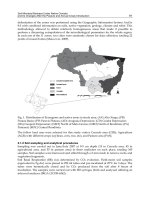
Dinh Hai commune is geographically
located in Tinh Gia district, Thanh Hoa
province, with latitude at 19.494830 and
longitude at 105.740970 as shown in Fig. 01.
The total area of Dinh Hai is estimated at about
2671.4 ha in which 378.2 ha is covered by
Pinus merkusii. Besides, Dinh Hai is wellknown as being a home for a variety of
animals, it is also known as one of the most
important income sources of local people, by
providing pine resin, food and regulating water
resources. Therefore, the study area is
significantly important for local livelihoods
and the environment.
Figure 01. Study area in Tinh Gia district, Thanh Hoa province
2.2. Methods
At first, a face to face interview was carried
out with managers and local people, then
secondary data were collected from previous
articles, reports and official documents to
investigate the current status and management
of Pinus merkusii up to 2015. Primary data in
this study was mainly obtained from semistructured interviews and open questions,
which were used to identify the challenges and
opportunities for PFES implementation. Thirty
households were randomly selected to collect
information from diverse groups of local
authorities, forest management agencies and
local people in Dinh Hai.
In order to satisfy the study objectives, 76
plots with dimension of 20 m x 25 m
(equivalent to 500 m2) and the assistance of
GPS Garmin 650 were set up and randomly
selected by ArcGIS 10.2 in Dinh Hai. Within
JOURNAL OF FORESTRY SCIENCE AND TECHNOLOGY NO. 5 - 2017
85
Management of Forest Resources and Environment
each plot, DBH of each Pinus merkusii tree
was measured at the breast height. In this
study, 150 points collected by GPS Garmin
650 were used for the map classification and
accuracy assessments. In particular, seventy
percent of averaged DBH values from 76 plots
is used for spatial interpolation, while 30% of
total GPS points and averaged DBH values
from plots are used for accuracy assessments
of classified map and interpolation method.
In addition, 2015 SPOT6 data was used to
construct current status map of Pinus merkusii
plantation by ArcGIS 10.2 with an
Unsupervised Classification method. Classified
map of Pinus merkusii was then used to
estimate its biomass and carbon stocks based
on the field-survey and Inverse Distance
Weighted interpolation approach (IDW).
Table 01. SPOT 6 data used this study
ID
1
2
Image ID
SPOT 6
DEM
IDW method was applied to estimate the
biomass and the carbon stocks in this study. To
estimate biomass, the following formula was
used, which indicates the strong correlation
between total tree biomass and D1.3 (Vu Tan
Phuong, 2011):
Tree biomass = 0.023 * D 1.32.9077 (kg/tree)
This equation indicates there is a strong
correlation between tree biomass and D1.3 with
high value of R2 (R2 = 0.9913). Therefore, this
formula was used to determine the biomass of
Pinus merkusii plantation.
Biomass (ton/ha) is defined by:
Biomass (ton ha-1) = (Tree biomass * Tree
density)/10,000
Where: Tree density is equal to the total
number of trees in 500 m2.
Carbon stocks are then calculated according
to the IPCC coefficients (IPCC, 2007):
C = 0.5 * Biomass (ton ha-1)
III. RESULTS AND DISCUSSIONS
3.1. Current status and the management
scheme of Pinus merkusii
Management scheme of Pinus merkusii in
Tinh Gia district:
Tinh Gia Protection Forest Management
Board (PFMB) includes director and two vice
86
Date
18/05/2015
2011
Spatial resolution (m)
1.5 x 1.5
30
directors who are responsible for directly
managing all activities according to the tasks
and all policies assigned by provincial and
state governments. Under Tinh Gia PFMB,
there are six local Forest Protection and
Management Stations (FPMS), which are
placed at six locations, namely Hai Linh. Hai
Nhan, Nguyen Binh, Truc Lam, Phu Lam and
Truong Lam. Surprisingly, Dinh Hai commune
has not had FPMS yet, but under the
management of Hai Linh. Not only Dinh Hai
but also other communes in Tinh Gia have not
applied PFES yet. Therefore, the question of
how the PFES is applied, has remained
unanswered.
Status of Pinus merkusii plantation:
As a result of Unsupervised Classification
approach of 2015 SPOT 6, the study has
constructed the status map of land covers in
which the spatial distribution and extents of
Pinus merkusii are classified and calculated at
378.2 ha (Fig. 02). This finding confirms that
Dinh Hai is the second largest area within 16
communes in Tinh Gia district, with 378.2 ha
of Pinus merkusii that accounts for 17% of
total Tinh Gia Protection Forest areas.
JOURNAL OF FORESTRY SCIENCE AND TECHNOLOGY NO. 5 - 2017
Management of Forest Resources and Environment
Figure 02. Status maps in Dinh Hai (87.0 % in accuracy, SPOT 6, 2015)
As a result, there were 76 plots selected and
established randomly, then investigated in
Dinh Hai commune (Fig. 03). To illustrate the
topographical distribution of Pinus merkusii,
DEM was used to classify the various
elevation values as shown in Figure 03.
Therefore, it can be easily seen Pinus merkusii
has geographically distributed at 3 main ranges
of altitude values, including 30 ÷ 63 m, 63 ÷
140 m and 140 ÷ 231 m. In addition, pine
density decreases gradually at the height above
sea level from 231 ÷ 329 m (Fig. 03) and
becomes unseen at the higher elevation. They
mainly distribute in the East, the West, the
South and the Southeast.
Figure 03. Spatial distribution of Pinus merkusii plots in different elevation values
JOURNAL OF FORESTRY SCIENCE AND TECHNOLOGY NO. 5 - 2017
87
Management of Forest Resources and Environment
The averaged DBH of each plot measured
in the study site is summarised in Table 02.
Table 02. Averaged DBH of Pinus merkusii in Dinh Hai
Plot ID
DBH (cm)
Plot ID
DBH (cm)
Plot ID
DBH (cm)
1
18.73
27
27.82
53
26.31
2
18.81
28
29.0
54
25.74
3
15.73
29
26.95
55
24.54
4
22.06
30
22.48
56
25.30
5
21.67
31
20.67
57
25.53
6
21.58
32
21.53
58
21.15
7
19.26
33
21.61
59
22.61
8
22.38
34
23.02
60
22.00
9
17.01
35
25.03
61
22.24
10
20.19
36
24.18
62
21.48
11
21.33
37
22.4
63
21.08
12
23.64
38
21.68
64
22.17
13
24.44
39
23.19
65
24.76
14
24.05
40
21.42
66
24.83
15
24.76
41
21.09
67
21.27
16
25.70
42
23.87
68
19.95
17
25.65
43
23.62
69
20.24
18
23.43
44
24.96
70
22.62
19
23.46
45
25.88
71
22.95
20
24.59
46
26.88
72
22.93
21
24.68
47
27.89
73
22.62
22
24.66
48
26.60
74
21.97
23
29.00
49
25.08
75
22.49
24
23.07
50
26.89
76
23.17
25
23.07
51
26.57
26
26.55
52
27.35
As shown in Table 02, the diameter of
Pinus merkusii is uneven. Findings have
shown that there are relatively large
differences in values of tree diameters due to
additional plantation. Based on field survey in
relation to D1.3, the study has summarised the
Descriptive Statistics of D1.3 in the field. As a
result, D1.3 has ranged from 15.73 ÷ 29 cm and
averaged at 23.38 cm in the study area. The
88
standard deviation is 2.60 cm, reflecting the
variance of D1.3, while standard errors is 0.77
cm, reflecting fluctuations in the average of
D1.3.
3.2. Estimation of biomass and carbon
stocks in Pinus merkusii
3.2.1. Estimation of biomass-based field
survey
Biomass estimation-based field survey:
JOURNAL OF FORESTRY SCIENCE AND TECHNOLOGY NO. 5 - 2017
Management of Forest Resources and Environment
As values of DBH measured are taken as an
average for the whole study area, the biomass
and carbon stocks are then calculated as shown
in Table 03.
Table 03. Summary of averaged DBH, biomass and carbon stocks in study sites
Study site
DBH
(cm)
Biomass
(ton)
Carbon stocks
(ton)
Dinh Hai
23.38 ± 2.6
136.4 ± 47.2
68.2 ± 23.6
3.2.2. Estimation of biomass and carbon
study area (Fig. 04), while 30% of total data
stocks-based IDW interpolation
was used to assess the accuracy of interpolated
Biomass estimation-based Inverse Distance
maps. In this study, Dinh Hai has two separate
Weighted Interpolation in Dinh Hai
sites, so interpolation and accuracy assessment
To construct the spatial maps of biomass
were conducted seperately as Dinh Hai A
and carbon stocks, 70 percent of plot-based
and Dinh Hai B as shown in Figure 04 and
survey was used to interpolate for the whole
Figure 05.
Figure 04. Biomass values of Pinus merkusii in Dinh Hai commune
As a result, the interpolated biomass shown
83.0% of map accuracies for Dinh Hai A and
that biomass of Pinus merkusii mostly range
Dinh Hai B defined, respectively. These
from 100 ÷ 200 ton ha-1 both in Dinh Hai A
findings confirm that the interpolation method
and Dinh Hai B, while the areas with biomass
is reliable and applicable for the biomass
-1
less than 100.0 ton ha and greater than 200.0
ton
ha-1
are
very
small.
As
accuracy
assessments indicated that there are 87.0% and
estimation in Dinh Hai commune.
Carbon
stocks
estimation-based
spatial
interpolation of Pinus merkusii:
JOURNAL OF FORESTRY SCIENCE AND TECHNOLOGY NO. 5 - 2017
89
Management of Forest Resources and Environment
Figure 05. Carbon stocks of Pinus merkusii in Dinh Hai commune (A) and (B)
Figure 05 shown that carbon stocks in Dinh
Hai A and Dinh Hai B are calculated at from
50.0 ÷ 100.0 ton ha-1, respectively. Similar to
the biomass, interpolation of carbon stocks
shown that the carbon stocks with range of
from 50 ÷ 100.0 ton ha-1 is dominant in both
Dinh Hai A and Dinh Hai B.
3.3. Challenges and opportunities for PFES
implementation in Tinh Gia district
Conducting the interviews with 30 of total
38 households in Dinh Hai has found that there
are a great potential for PFES implementation
in Dinh Hai commune in particular and Tinh
Gia in general. However, study area still has
numerous challenges in pursuing PFES
implementation as summarized in Table 04.
Table 04. SWOT analysis for PFES application in Tinh Gia district
Strengths
Weaknesses
Dinh Hai’s plantation covered almost
The thick litter and shrub may lead to
17.5%, equivalent to 378.18 ha in the Tinh increasing frequencies of forest fire and outbreak
Gia Protection Forest.
of diseases.
Both district and local authorities as
well as local people are highly aware of
values of forest protection and understand
importance of forest policies in relation to
forest management and protection.
There is a strong cooperation and
connection between authorities and local
people; forest owners are allowed to exploit
pine resin and are responsible for managing
their allocated forest area.
90
There is a current lack of evaluation
indicators, such as monitoring systems, policy
guidelines, economic instrument related to
biodiversity, watershed and carbon sequestration,
may lead to weaken forest management in study
site.
Payments for managing allocated one ha of
forest, about 70,000 VND is quite lower than other
provinces1, may lead to discouragement of local
participation.
JOURNAL OF FORESTRY SCIENCE AND TECHNOLOGY NO. 5 - 2017
Management of Forest Resources and Environment
Opportunities
Threats
Based on the data collected, total
Difficult to quantify the value of forest
estimation of CO2 for the whole study area is environmental services.
about 1,959,622.37 tons, which are a great
Unable to manage all of PFES users.
opportunity to participate on international
Lack of commitment
and compliance
carbon market, such as REDD+, PFES, so between forest owner and PFES user as the
Dinh Hai may get additional fundings for boundary is still unclearly and legally defined.
carrying
out
forest
management
and
protection activities.
The PFES implementation procedures are
time-consuming that may prevent the authorities’
Effective implementation of PFES may determination from pursuing PFES.
improve the quantity and quality of forests,
thus contributing to better manage forest
resources in Tinh Gia district.
Financial assistance from PFES is more
likely to increase local livelihoods in Dinh Hai.
1
PFES report in Vietnam from 2011-2014.
3.4. Recommendations for PFES implementation
from Lam Dong and Lai Chau shoud be learnt
in Tinh Gia and Thanh Hoa province
for Dinh Hai commune. This is because
Based on the findings, it can be said that
maximum benefits from PFES will lead to
there is an enormous importance of Pinus
significantly improve the livelihoods of local
merkusii for implementing PFES policy.
people, thus contributing to better forest
Therefore,
PFES
protection and management. Consequently,
implementation is significant in Dinh Hai,
local people are more likely to be active in
Tinh Gia district in particular. Firstly, local
guarding their assigned forest and more
authorities and local households should be
responsible for their allocated forest areas.
encouraged to participate in all REDD+ and
Thirdly, the management and administration
PFES activities to receive additional financial
schemes should be set up in a way of
support for better forest protection and
encouraging local people to protect and
development. Besides, another important role
monitor forest resources by clear guidance of
of pine forest as a function of water regulation
social policies and techniques to develop forest
should be included when estimating Pinus
resources.
solutions
for
how
merkusii values in Thanh Hoa in general and
Tinh Gia in particular.
Secondly, the Payments mechanism for
forest environmental services as good samples
Based on the field measurements, the study
has estimated the amount of carbon stocks and
calculated the commercial value of Pinus merkusii
in Dinh Hai commune as shown in Table 05.
JOURNAL OF FORESTRY SCIENCE AND TECHNOLOGY NO. 5 - 2017
91
Management of Forest Resources and Environment
Table 05. Proposed estimation of carbon stocks and commercial values of Pinus merkusii
Items
Pinus merkusii
Total absorbed CO2
Price
Values
378.2 ha
1,959,622.37 (ton)
$5/ton
Conversion
(Up to 10/07/2017 at 12:30pm by Vietcombank)
Total estimated
1USD = 22,449 VND
219,957,812,920.65 (VND)
Source: Adapted from Vu Tan Phuong (2006).
PFES mechanism also should be applied in
line with what the forest offers. Carbon stocks
of Pinus merkusii should be paid as the selling
price of carbon credits on the market, which is
now from 5 ÷ 10 USD ton-1 in consultation
with payments rate implemented in some
provinces. For example, Lai Chau has paid an
average price of 342,734 VND ha-1 year-1, an
average of Lam Dong province is 342,500
VND ha-1 year-1. In Binh Dinh province, the
averaged price paid was 303,259 VND ha-1
year-1 (PFES Report in Vietnam from 2011 to
2014).
IV. CONCLUSIONS
SPOT 6 offers a great opportunity for
constructing forest covers, estimating biomass
and carbon stocks through Inverse Distance
Weighted Interpolation approach known as
IDW. By using 2015 SPOT 6, study has
successfully constructed the status map of
Pinus merkusii plantation in Dinh Hai
commune. As a result of accuracy assessment
shown that there are relatively high accuracy
of Pinus merkusii cover, about 87.0% in 368.2
ha in study area. Similarly, there are around
87.0% and 83.0 % of interpolated biomass
map, indicating this method is reliable and
should be applied to estimate biomass and
carbon stocks in Dinh Hai.
The high values of biomass and carbon
stocks offer a great potential on carbon trading
values. The higher carbon stocks values and
92
the larger commercial value that Pinus
merkusii will provide forest owners more
incomes, which significantly improve forest
management and protection if PFES
implemented in this area.
Acknowledgement
We would like to express our gratitude to
the staff and local people in Dinh Hai
commune for the enthusiastic support during
our works conducted as well as and special
thanks to Ms. Tran Thi Phuong Thuy and Ms.
Tran Thi Chau for supporting us to collect
data.
REFERENCES
1. Bao Huy (2014). Develop a method for measuring
and monitoring forest carbon with community
participation in Vietnam. Journal of Forest and
Environment, 44:34-45 (Vietnamese languague).
2. Bao Huy (2016). Using SPOT 5 and GIS to
estimate and monitor evergreen broad-leaf forest
biomass and carbon stocks in Tay Nguyen. Journal of
Vietnam Science and Technology 9(676):52-59
(Vietnamese languague).
3. Decision No 380/QĐ-TTg of Prime Minister dated
10 April 2008 on the Payments on Forest Environmental
Services policy (Vietnamese languague).
4. Tran Quang Bao, Le Thai Sơn. (2013). Using
highly spatial resolution data to determine the forest
distribution and its storage of carbon stocks., Journal of
Agriculture and Rural Development, 63-72 (Vietnamese
languague).
5. Vu Tan Phuong (2010). Develop a model to
estimate single biomass of Pinus kesiya forest in Su Phi
district, Ha Giang province. Journal of Forest Science
(Vietnamese languague).
JOURNAL OF FORESTRY SCIENCE AND TECHNOLOGY NO. 5 - 2017
Management of Forest Resources and Environment
6. Chave, J., Andalo, C., Brown, S., Cairns, M. A.,
Chambers, J. Q., Eamus, D., Lescure, J. P (2005). Tree
allometry and improved estimation of carbon stocks and
balance in tropical forests. Oecologia, 145(1), 87-99.
7. Goetz, S., Dubayah, R. (2011). Advances in
remote sensing technology and implications for
measuring and monitoring forest carbon stocks and
change. Carbon Management, 2(3), 231-244.
8. Kiyono, Y., Furuya, N., Sum, T., Umemiya, C.,
Itoh, E., Araki, M., Matsumoto, M. (2010). Carbon stock
estimation by forest measurement contributing to
sustainable forest management in Cambodia. Japan
Agricultural Research Quarterly: JARQ, 44(1), 81-92.
9. Myeong, S., Nowak, D. J., & Duggin, M. J.
(2006). A temporal analysis of urban forest carbon
storage using remote sensing. Remote Sensing of
Environment, 101(2), 277-282.
10. Roy, P. S., & Ravan, S. A. (1996). Biomass
estimation using satellite remote sensing data—an
investigation on possible approaches for natural forest.
Journal of biosciences, 21(4), 535-561.
11. Saatchi, S. S., Harris, N. L., Brown, S., Lefsky,
M., Mitchard, E. T., Salas, W., Petrova, S (2011).
Benchmark map of forest carbon stocks in tropical
regions across three continents. Proceedings of the
National Academy of Sciences, 108(24), 9899-9904.
12. Smith, J., & Scherr, S. J. (2002). Forest carbon
and local livelihoods: assessment of opportunities and
policy recommendations (No. CIFOR Occasional Paper
no. 37, p. 45p).
SỬ DỤNG ẢNH SPOT 6 ƯỚC TÍNH SINH KHỐI
VÀ TRỮ LƯỢNG CACBON RỪNG THÔNG TRỒNG THUẦN LOÀI
TẠI XÃ ĐỊNH HẢI, HUYỆN TĨNH GIA, TỈNH THANH HÓA
Nguyễn Hữu Nghĩa1, Nguyễn Hải Hòa2, Lê Thành An3,
Trần Thị Ngọc Lan4, Amena Easmin5, Nguyễn Thị Minh Tú6
1,2,3,4,6
5
Trường Đại học Lâm nghiệp
Đại học Stamford, Bangladesh
TÓM TẮT
Nghiên cứu này cho thấy tiềm năng ứng dụng của ảnh vệ tinh độ phân giải cao SPOT 6 trong ước tính sinh khối
và trữ lượng cácbon cho rừng trồng Thông nhựa (Pinus merkusii) tại huyện Tĩnh Gia, tỉnh Thanh Hóa. Từ thực
trạng tại khu vực nghiên cứu đã chỉ ra rằng bản đồ sinh khối và trữ lượng cácbon được xây dựng với độ chính
xác khá cao (trên 83%) để ước tính CO2 và đề xuất phương án hợp lý cho việc áp dụng PFES tại địa phương.
Kết quả nghiên cứu khẳng định phương pháp nội suy nghịch đảo khoảng cách có trọng số có độ tin cậy và có
thể áp dụng cho Định Hải. Bằng điều tra thực địa tại 76 ô tiêu chuẩn trong khu vực nghiên cứu kết hợp cùng
phương pháp nghịch đảo khoảng cách có trọng số (IDW) đã chỉ ra rằng trữ lượng cácbon tại khu vực nghiên
cứu là rất lớn so với những điều tra tại các tính khác, khoảng 1,959,622.37 tấn tương ứng với số tiền
219,957,812,920.65 VND, kết quả này cho thấy tiềm năng phát triển kinh tế cũng như nâng cao đời sống người
dân địa phương của rừng khi Tinh Gia tham gia vào thị trường cácbon. Bên cạnh những tiềm năng tham gia thị
trường cácbon, hiện tại PFES chưa được áp dụng tại huyện Tĩnh Gia. Do vậy, việc nghiên cứu nhằm cung cấp
cơ sở tính toán, đánh giá cụ thể về những tiềm năng trên của cơ chế PFES cho các nhà hoạch định chính sách là
rất cần thiết để có thể sớm áp dụng PFES tại huyện Tĩnh Gia nói riêng và tỉnh Thanh Hóa nói chung.
Từ khóa: PFES, rừng phòng hộ Tĩnh Gia, sinh khối, SPOT 6, thị trường Carbon, trữ lượng Carbon.
Received
Revised
Accepted
: 19/7/2017
: 09/9/2017
: 25/9/2017
JOURNAL OF FORESTRY SCIENCE AND TECHNOLOGY NO. 5 - 2017
93