ngoc mai task 1 test 3
Bạn đang xem bản rút gọn của tài liệu. Xem và tải ngay bản đầy đủ của tài liệu tại đây (28.99 KB, 1 trang )
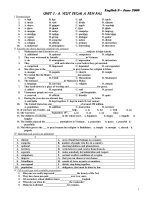
The diagrams illustrate how West Park Secondary School has
developed since 1950 when it was built to 2010.
Overall, it is clear that the biggest change at school was the
enlargement of parking space. However the school did not saw the
development of its recreational facilities.
In 1950, the school was a single building located along the main road.
There was a large playground which was located right behind the
school building to the right of farmland. Thirty years later in 1980, the
houses were demolished and replaced by a car park and a new science
block. The farmland was also replaced by a new sports field, but the
playground remained unchanged.
From 1980 to 2010, the car park was extended, as a result the sports
field move to the East and the playground became smaller. However,
the science block and the main building of the school still remain
along the main road.