Advances in Theory and Applications of Stereo Vision Part 10 ppsx
Bạn đang xem bản rút gọn của tài liệu. Xem và tải ngay bản đầy đủ của tài liệu tại đây (3.25 MB, 25 trang )
Detecting Human Activity b y Location System and Stereo Vision 13
4. Quick calibration method for ultrasonic 3D tag system
4.1 M easurement and calibration
In the ultrasonic 3D tag system that the authors have developed, calibration means calculation
of receivers’ positions and measurement means calculation of transmitters’ positions as shown
in Fig. 14. Essentially, both problems are the same. As described in the previous section,
the robustness of the ultrasonic 3D tag system can be improved by increasing the number of
ultrasonic receivers. However, as the space where the receivers exist widens, it becomes more
difficult to calibrate receivers’ positions because a simple calibration method requires almost
the same size of a calibration device which has multiple transmitters. This paper describes
a calibration method which requires relatively small number of transmitters such as three or
more and therefore doesn’t require the same size of the calibration system as that of the space
where the receivers exist.
Measurement
Calibration
L
Pt
Pr
Transmitters
Receivers
||
i,
j
L−=
ij
Pr Pt
Fig. 14. Calibration and measurement
4.2 Q uick calibration method
In the present paper, we describes ”a global calibration based on local calibration (GCLC)”
method and two constraints that can be used in conjunction with the GCLC method.
The procedure for GCLC is described below.
1. Move the calibration device arbitrarily to multiple positions (A, B, and C in Fig. 15).
2. Calculate the positions of the receivers in a local coordinate system, with the local origin
set at the position of the calibration system. The calculation method was described in the
previous section.
3. Select receivers for which the positions can be calculated from more than two calibration
system positions.
4. Select a global coordinate system from among the local coordinate systems and calculate the
positions of the calibration device in the global coordinate system using the receivers selected
in Step 3. Then, calculate transformation matrices (M
1
and M
2
in Fig. 15).
5. Calculate the receiver positions using the receiver positions calculated in Step 2 and the
transformation matrices calculated in Step 4.
Steps 4 are described in detail in the following.
215
Address-Event based Stereo Vision with Bio-inspired Silicon Retina Imagers
14 Stereo Vision
M2
M1
Receivers
Calibration device
(Transmitters)
Place A
Place B
Place C
0
Fig. 15. Quick calibration method
4.3 D etails of qui ck calibration
4.3.1 Calculating the positions of the calibration device in the global coordinate system
(Step 4)
The error function E can be defined as follows:
E
=
n
∑
i=0
n
∑
j=i+1
||M
i
P
(i,j)
i
− M
j
P
(i,j)
j
||
2
, (13)
where M
i
is the transformation matrix from the local coordination system i to the global
coordination system, and P
(i,j)
j
denotes points in the local coordination system j for the case in
which the points can be calculated in both local coordination systems i and j.
∂E
∂M
i
=
∂
∂M
i
n
∑
j
=0
(i=j)
Tr
M
i
P
(i,j)
i
− M
j
P
(i,j)
j
T
M
i
P
(i,j)
i
− M
j
P
(i,j)
j
=
∂
∂M
i
n
∑
j
=0
(i=j)
Tr
−(M
j
P
(i,j)
j
)
T
M
i
P
(i,j)
i
− (M
i
P
(i,j)
i
)
T
M
j
P
(i,j)
j
+(M
i
P
(i,j)
i
)
T
M
i
P
(i,j)
i
+(M
j
P
(i,j)
j
)
T
M
j
P
(i,j)
j
= −2M
0
P
(i,n)
0
(P
(i,n )
i
)
T
−···−2M
i
−1
P
(i,i−1)
i−1
(P
(i,i−1)
i−1
)
T
+2M
i
n
∑
j
=0
(i=j)
P
(i,j)
i
(P
(i,j)
i
)
T
−2M
i
+1
P
(i,i+1)
i+1
(P
(i,i+1)
i
)
T
−···−2M
n
P
(i,n)
n
(P
(i,n)
i
)
T
.
(14)
If we select the local coordinate system 0 as the global coordinate system, M
0
becomes an
identity matrix. From Eq. (14), we can obtain simultaneous linear equations and calculate M
i
using Eq. (15),
M
1
M
2
··· M
n
=
P
(0,1)
0
(P
(0,1)
1
)
T
P
(0,2)
0
(P
(0,2)
2
)
T
··· P
(0,n)
0
(P
(0,n)
n
)
T
×
⎛
⎜
⎜
⎜
⎜
⎜
⎜
⎜
⎜
⎜
⎜
⎜
⎜
⎝
n
∑
i
=0
P
(1,i)
1
(P
(1,i)
1
)
T
−P
(1,2)
1
(P
(1,2)
2
)
T
··· −P
(1,n)
1
(P
(1,n)
n
)
T
−P
(1,2)
2
(P
(1,2)
1
)
T
n
∑
i
=0
P
(2,i)
2
(P
(2,i)
2
)
T
··· −P
(2,n)
2
(P
(2,n)
n
)
T
.
.
.
.
.
.
.
.
.
.
.
.
−P
(1,n)
n
(P
(1,n)
1
)
T
−P
(2,n)
n
(P
(2,n)
2
)
T
···
n
∑
i
=0
P
(n,i)
n
(P
(n,i)
n
)
T
⎞
⎟
⎟
⎟
⎟
⎟
⎟
⎟
⎟
⎟
⎟
⎟
⎟
⎠
−1
.
(15)
216
Advances in Theory and Applications of Stereo Vision
Detecting Human Activity b y Location System and Stereo Vision 15
4.4 C onsidering the environment boundary condition
Regarding the GCLC method as presented above, the error of calibration will accumulate as
the space in which the ultrasonic receivers are placed becomes larger. Therefore, the number
of moving calibrating devices becomes larger. For example, if we place receivers on the ceiling
of a corridor of size 2 x 30 m, the accumulated error may be large. This section describes the
boundary constraint with which we can reduce the error accumulation.
In most cases, the ultrasonic location system will be placed in a building or on the components
of a building, such as on a wall or ceiling. If we can obtain CAD data of the building or its
components or if we can measure the size of a room inside the building to a high degree of
accuracy, then we can use the size data as a boundary condition for calibrating the receiver
positions.
Here, let us consider the boundary constraint shown in Fig. 16. We can formulate this problem
using the Lagrange’s undecided multiplier method as follows:
E
=
3
∑
i=0
3
∑
j=i+1
M
i
P
(i,j)
i
− M
j
P
(i,j)
j
2
+ λF(M
3
),
(16)
F(M
3
)=
(
M
3
P
b1
− P
b0
)
·
n + l
0
− l
1
= 0(17)
where λ denotes a Lagrange’s undecided multiplier. By solving this equation, we can obtain
the following equations:
M
1
M
2
M
3
=
P
(0,1)
0
(P
(0,1)
1
)
T
0
−1/2λnP
T
b1
×
⎛
⎜
⎜
⎜
⎜
⎜
⎜
⎜
⎜
⎜
⎝
P
(0,1)
1
(P
(0,1)
1
)
T
+P
(1,2)
1
(P
(1,2)
1
)
T
−P
(1,2)
1
(P
(1,2)
2
)
T
0
−P
(1,2)
2
(P
(2,1)
1
)
T
P
(1,2)
2
(P
(1,2)
2
)
T
+P
(2,3)
2
(P
(2,3)
2
)
T
−P
(2,3)
2
(P
(2,3)
3
)
T
0
−P
(2,3)
3
(P
(2,3)
2
)
T
P
(2,3)
3
(P
(2,3)
3
)
T
⎞
⎟
⎟
⎟
⎟
⎟
⎟
⎟
⎟
⎟
⎠
−1
. (18)
By substituting M
3
into Eq. (17), we can solve λ and eliminate it from Eq. (18).
The general case of the GCLC method with multiple boundary constraints is as follows:
1
M
2
M
3
M
Global coordinate
n
b0
P
b1
P
Wall, floor, or ceiling of building
In case of are constrained
as the basis for .
0
l
1
l
b0
P
b1
P
()
01
ll −=⋅− nPP
b0b1
Fig. 16. Example of a boundary condition as the basis for the building
217
Address-Event based Stereo Vision with Bio-inspired Silicon Retina Imagers
16 Stereo Vision
M
1
M
2
··· M
n
=
⎛
⎜
⎜
⎝
P
(0,1)
0
(P
(0,1)
1
)
T
−1/2
n
i
∑
i
=0
λ
1,i
n
1,i
P
T
1,i
··· ···
P
(0,n)
0
(P
(0,n)
n
)
T
−1/2
n
n
∑
i
=0
λ
n,i
n
n,i
P
T
n,i
⎞
⎟
⎟
⎠
×
⎛
⎜
⎜
⎜
⎜
⎜
⎜
⎜
⎜
⎜
⎜
⎜
⎜
⎜
⎜
⎜
⎜
⎜
⎝
n
∑
i
=0
i
=1
P
(1,i)
1
(P
(1,i)
1
)
T
−P
(1,2)
1
(P
(1,2)
2
)
T
··· −P
(1,n)
1
(P
(1,n)
n
)
T
−P
(1,2)
2
(P
(1,2)
1
)
T
n
∑
i
=0
i
=2
P
(2,i)
2
(P
(2,i)
2
)
T
··· −P
(2,n)
2
(P
(2,n)
n
)
T
.
.
.
.
.
.
.
.
.
.
.
.
−P
(1,n)
n
(P
(1,n)
1
)
T
−P
(2,n)
n
(P
(2,n)
2
)
T
···
n
∑
i
=0
i
=n
P
(n,i)
n
(P
(n,i)
n
)
T
⎞
⎟
⎟
⎟
⎟
⎟
⎟
⎟
⎟
⎟
⎟
⎟
⎟
⎟
⎟
⎟
⎟
⎟
⎠
−1
, (19)
where λ
i,j
,n
i,j
,andP
i,j
denote the j-th undecided multiplier, the j-th constraint vector, and
the j-th constrained point in the i-th local coordinate system, respectively. In this case, the
boundary constraints are as follows:
F
i,j
=
M
i
P
i,j
−P
b0
· n
i,j
− Δ l
i,j
= 0, (20)
where Δl
i,j
denotes a distance constraint. The above GCLC method with boundary constraints
is applicable to, for example, the case in which more complex boundary conditions exist, as
shown in Fig. 17.
1
M
2
M
3
M
Global coordinate
Wall, floor, ceiling of building
b0
P
0
l
b1
P
b2
P
1
n
2
n
1
l
2
l
3
l
4
l
5
l
Fig. 17. Example of a greater number of boundary conditions as the basis of the building
4.5 E xperimental results of GCLC
4.5.1 Method for error evaluation
e1
e2
en
True positions
Calculated positions
Fig. 18. Method for calculating error
Figure 18 shows the method used to calculate error. The distances between the calculated
receiver positions and the true receiver positions are denoted by e
1
, e
2
, ··· , e
n
. The average
error is defined by
E
=
1
n
n
∑
i=1
e
i
. (21)
218
Advances in Theory and Applications of Stereo Vision
Detecting Human Activity b y Location System and Stereo Vision 17
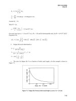
4.5.2 Accuracy evaluation
Calibration was performed in a room (4.0×4.0×2.5 m) having 80 ultrasonic receivers
embedded in the ceiling. Figure 19 shows the experimental results obtained using the GCLC
method without any constraints. The authors performed calibration at 16 points in the
room. Seventy-six receivers were calculated. In the figure, the red spheres indicate calculated
receiver positions, the black crosses indicate the true receiver positions, and the blue spheres
indicate the positions of the calibration device. Figure 20 shows the experimental results for
the GCLC method considering directivities. Seventy-six receivers were calculated. Table 1
shows the average error E, maximum error, and minimum error for these methods. The above
results show that using the GCLC method we can calibrate the position of receivers placed in
a space of average room size and that the error can be reduced significantly by considering
directivity.
Another calibration was performed in a rectangular space (1.0
×4.5) having a longitudinal
length that is much longer than its lateral length. Seventy-six ultrasonic receivers are
embedded in the space. Figure 21 shows the experimental results obtained using the GCLC
method without any constraints. Seventy-five receivers were calculated. Figure 22 shows
the experimental results obtained using the GCLC method with directivity consideration and
a boundary constraint. Table 2 shows the average error E, maximum error, and minimum
error for these methods. The above results show that with the GCLC method with directivity
consideration and boundary constraint has a significantly reduced error.
-1000
0
1000
2000
-3000
-2000
-1000
0
0
500
1000
1500
x
y
[mm]
[mm]
[mm]
calculated receiver positions
true receiver positions
positions of the calibration device
Fig. 19. Experimental result obtained by the GCLC method
-1000
0
1000
2000
-3000
-2000
-1000
0
0
500
1000
z
x
y
[mm]
[mm]
[mm]
calculated receiver positions
true receiver positions
positions of the calibration device
Fig. 20. Experimental result obtained by the GCLC method considering directivity
4.6 Advantages of the GCLC method
The advantages of the GCLC method are listed below.
– The method requires a relatively small number of transmitters, at least three transmitters,
so that the user can calibrate the ultrasonic location system using a small calibrating device
having at least three transmitters.
– The method can calibrate the positions of the receivers independent of room size.
219
Address-Event based Stereo Vision with Bio-inspired Silicon Retina Imagers
18 Stereo Vision
Ave. Max. Min.
error error error
GCLC 195
mm
399
mm
66
mm
GCLC
with directivity consideration 75
mm
276
mm
9mm
Table 1. Errors (mm) of the proposed method for the case of a square-like space
0
500
1000
1500
2000
0
1000
2000
3000
4000
0
200
400
600
800
1000
1200
1400
1600
1800
2000
Origin of global coordinate system
Fig. 21. Experimental results obtained by the GCLC method
0
500
1000
1500
2000
0
1000
2000
3000
0
200
400
600
800
1000
1200
1400
1600
1800
Origin of global coordinate system
Reference point
Constrained point
Directions of constraint
Fig. 22. Experimental results obtained by the GCLC method with directivity consideration
and a boundary constraint
Ave. Max. Min.
error error error
GCLC 236
mm
689
mm
17
mm
GCLC
with directivity consideration
and boundary constraint 51
mm
121
mm
10
mm
Table 2. Errors (mm) of the proposed method for the case of a rectangular space having a
longitudinal length that is much longer than its lateral length
220
Advances in Theory and Applications of Stereo Vision
Detecting Human Activity b y Location System and Stereo Vision 19
– The error can be reduced by considering the directivity constraint. The constraint is useful
for cases in which the ultrasonic location system adopts a method in which the time-of-fight
is detected by thresholding ultrasonic pulse.
– The error can be reduced by considering the boundary constraint. The constraint is useful
for cases in which the receivers to be calibrated are placed in a rectangular space having a
longitudinal length that is much greater than the lateral length, such as a long corridor.
4.7 D evelopment of Ultrasonic Portable 3D Tag System
The GCLC method enables a portable ultrasonic 3D tag system. Figure 23 shows a portable
ultrasonic 3D tag system, which consists of a case, tags, receivers, and a calibration device.
The portable system enables measurement of human activities by quickly installing and
calibrating the system on-site, at the location where the activities actually occur.
Ultrasonic sensors
Calibration device
built in sections
Portable case
Fig. 23. Developed portable ultrasonic 3D tag system
5. Quick registration of human activity events to be detected
This section describes quick registration of target human activity events. Quick registration
is performed using a stereoscopic camera with ultrasonic 3D tags as shown in Fig. 24 and
interactive software. The features of this function lie in simplification of 3D shape, and
simplification of physical phenomena relating to target events. The software abstracts the
shapes of objects in real world as simple 3D shape such as lines, circles, or polygons. In order
to describe the real world events when a person handles the objects, the software abstracts the
function of objects as simple phenomena such as touch, detouch, or rotation. The software
adopts the concept of virtual sensors and effectors to enable for a user to define the function
of the objects easily by mouse operations.
221
Address-Event based Stereo Vision with Bio-inspired Silicon Retina Imagers
20 Stereo Vision
For example, if a person wants to define the activity of ”put a cup on the desk”, firstly,
the person simplifies the cup and the desk as a circle and a rectangle respectively using a
photo-modeling function of the software. Second, using a function for editting virtual sensors,
the person adds a touch type virtual sensor to the rectangle model of the desk, and adds a bar
type effector to the circle model of the cup.
5.1 S oftware for quick registration of human activity events to be detected
5.1.1 Creating simplified 3D shape m odel
Figure 26 shows examples of simplified 3D shape models of objects such as a Kleenex, a cup, a
desk and stapler. The cup is expressed as a circle and the desk is a rectangle. The simplification
is performed using a stereoscopic camera with the ultrasonic 3D tags and a photo-modeling
function of the software. Since the camera has multiple ultrasonic 3D tags, the system can
track its position and posture. Therefore, it is possible to move the camera freely when the
user creates simplified 3D shape models and the system can integrate the created 3D shape
models in a world coordinate system.
5.1.2 Creating model of physical object’s function using virtual sensors/effectors
The software creates the model of a object’s function by attaching virtual sensors/effectors
which are prepared in advance in the software to the 3D shape model created in step (a).
Virtual sensors and effectors work as sensors and ones affecting the sensors on computer.
The current system has ”angle sensor” for detecting rotation, ”bar effector” for causing
phenomenon of touch, ”touch sensor” for detecting phenomenon of touch. In the right part of
Fig. 27, red bars indicate a virtual bar effector, and green area indicates a virtual touch sensor.
By mouse operations, it is possible to add virtual sensors/effectors to the created 3D shape
model.
5.1.3 Associating output of model of physical object’s function with activity event
Human activity can be described using output of the virtual sensors which are created in Step
(b). In Fig. 28, red bar indicates that the cup touches with the desk and blue bar indicates
that the cup doesn’t touch with the desk. By creating the table describing relation between
the output of the virtual sensors and the target events, the system can output symbolic
information such as ”put a cup on the desk” when the states of virtual sensors change.
5.1.4 Detecting human activity event in real t ime
When the software inputs position data of ultrasonic 3D tag, the software can detect the target
events using the virtual sensors and the table defined in Step (a) to (c) as shown in Fig. 29
6. Conclusion
This paper described a system for quickly realizing a function for robustly detecting daily
human activity events in handling objects in the real world. The system has three functions: 1)
robustly measuring 3D positions of the objects, 2) quickly calibrating a system for measuring
3D positions of the objects, 3) quickly registering target activity events, and 4) robustly
detecting the registered events in real time.
As for 1), In order to estimate the 3D position with high accuracy, high resolution, and
robustness to occlusion, the authors propose two estimation methods, one based on a
least-squares approach and one based on RANSAC.
222
Advances in Theory and Applications of Stereo Vision
Detecting Human Activity b y Location System and Stereo Vision 21
Ultrasonic 3D tag
Stereoscopic camera
Fig. 24. UltraVision (a stereoscopic camera with the ultrasonic 3D tags) for creating
simplified 3D shape model
+OCIGUHTQOUVGTGQUEQRKEECOGTC
5RGEKHKPIEJCTCEVGTKUVKERQKPVU
Fig. 25. Photo-modeling by stereoscopic camera system
Fig. 26. Create simplified shape model
223
Address-Event based Stereo Vision with Bio-inspired Silicon Retina Imagers
22 Stereo Vision
$CT'HHGEVQT
6QWEJ5GPUQT
$CT'HHGEVQTVWTPUTGF
YJGPKVKUVQWEJKPIYKVJ6QWEJ5GPUQT
Fig. 27. Create model of physical object’s function using virtual sensors/effectors
The system was tested in an experimental room fitted with 307 ultrasonic receivers; 209 in
the walls and 98 in the ceiling. The results of experiments conducted using 48 receivers
in the ceiling for a room with dimensions of 3.5
× 3.5 × 2.7 m show that it is possible to
improve the accuracy, resolution, and robustness to occlusion by increasing the number of
ultrasonic receivers and adopting a robust estimator such as RANSAC to estimate the 3D
position based on redundant distance data. The resolution of the system is 15 mm horizontally
and 5 mm vertically using sensors in the ceiling, and the total spatially varying position error
is 20–80 mm. It was also confirmed that the system can track moving objects in real time,
regardless of obstructions.
As for 2), this paper described a new method for quick calibration. The method uses a
calibration device with three or more ultrasonic transmitters. By arbitrarily placing the device
at multiple positions and measuring distance data at their positions, the positions of receivers
can be calculated. The experimental results showed that with the method, the positions of 80
receivers were calculated by 4 transmitters of the calibration device and the position error is
103 mm.
As for 3), this paper described a quick registration of target human activity events in handling
objects. To verify the effectiveness of the function, using a stereoscopic camera with ultrasonic
3D tags and interactive software, the authors registered activities such as ”put a cup on the
#EVKXKV['XGPV
GZ;QWRWVVJGEWRQPVJGYJKVGVCDNG
$CT'HHGEVQTVQWEJGU6QWEJ5GPUQT
Fig. 28. Associate output of virtual sensors with target activity event
224
Advances in Theory and Applications of Stereo Vision
Detecting Human Activity b y Location System and Stereo Vision 23
Functional model
Position data
from ultrasonic tag system
Input
Simplified shape model
Physical function model
The number of tags and their IDs
Hold blue cup
Move three physical objects
Rotate stapler
Fig. 29. Recognize human activity in real time by function’s model
desk” and ”staple document” through creating the simplified 3D shape models of ten objects
suchasaTV,adesk,acup,achair,abox,andastapler.
Further development of the system will include refinement of the method for measuring
the 3D position with higher accuracy and resolution, miniaturization of the ultrasonic
transmitters, development of a systematic method for defining and recognizing human
activities based on the tagging data and data from other sensor systems, and development
of new applications based on human activity data.
7. References
[1] T. Hori. Overview of Digital Human Modeling. Proceedings of 2000 IEEE/RSJ International
Conference on Intelligent Robots and Systems (IROS2000), Workshop Tutorial Note, pp. 1–14,
2000
[2] H. Mizoguchi, T. Sato, and T. Ishikawa. Robotic Office Room to Support Office Work
by Human Behavior Understanding Function with Networked Machines. IEEE/ASME
Transactions on Mechatronics, Vol. 1, No. 3, pp. 237–244, September 1996
[3] Y. Nishida, H. Aizawa, T. Hori, N.H. Hoffman, T. Kanade, M. Kakikura, “3D Ultrasonic
225
Address-Event based Stereo Vision with Bio-inspired Silicon Retina Imagers
24 Stereo Vision
Tagging System for Observing Human Activity, ” in Proceedings of IEEE International
Conference on Intelligent Robots and Systems (IROS2003), pp. 785-791, October 2003.
[4] A. Ward, A. Jones, A. Hopper, “A New Location Technique for the Active Office, ” IEEE
Personal Communications, Vol. 4, No. 5, pp. 42-47, October 1997.
[5] A. Harter, A. Hopper, P. Steggles, A. Ward, P. Webster, “The Anatomy of a Context-Aware
Application, ” in Proceedings of the ACM/IEEE MobiCom, August 1999.
[6] M. Addlesee, R. Curwen, S. Hodges, J. Newman, P. Steggles, A. Ward, A. Hopper,
“Implementing a sentient computing system, ” IEEE Computer, Vol. 34, No. 8, pp. 50-56,
August 2001.
[7] M. Hazas and A. Ward, “A Novel Broadband Ultrasonic Location System, ” in Proceedings
of UbiComp 2002, pp. 264-280, September 2002.
[8] N.B. Priyantha, A. Chakraborty, H. Balakrishnan, “The Cricket Location-Support system,
”inProceedings of the 6th International Conference on Mobile Computing and Networking
(ACM MobiCom2000), pp. 32-43, August 2000
[9] A. Mahajan and F. Figueroa, “An Automatic Self Installation and Calibration Method for
a 3D Position Sensing System using Ultrasonics,” Robotics and Autonomous Systems,Vol.
28, No. 4, pp. 281-294, September 1999.
[10] Y. Fukuju, M. Minami, H. Morikawa, and T. Aoyama, “DOLPHIN: An Autonomous
Indoor Positioning System in Ubiquitous Computing Environment, ” in Proceedings of
IEEE Workshop on Software Technologies for Future Embedded Systems (WSTFES2003), pp.
53-56, May 2003.
[11] P. Duff, H. Muller, “Autocalibration Algorithm for Ultrasonic Location Systems,” in
Proceedings of 7th IEEE International Symposium on Wearable Computer, pp. 62-68, October
2003.
[12] Y. Chen, G. Medioni, “Object Modeling by registration of multiple range images,” Image
and Vision Computing, Vol. 10, No. 3, pp. 145-155, April 1992.
[13] P.J. Neugebauer, “Geometrical Cloning of 3D Objects via Simultaneous Registration
of Multiple Range Images,” in Proceedings of the 1997 International Conference on Shape
Modeling and Application (SMA’97), pp. 130-139, 1997.
[14] B.W. Parkinson, J.J. Spilker, P. Axelrad, P. Enge, The Global Positioning System: Theory and
Applications, American Institute of Aeronautics and Astronautics, 1996.
[15] K.C. Ho. Solution and Performance Analysis of Geolocation by TDOA. IEEE Transaction
on Aerospace and Electronic Systems, Vol. 29, No. 4, pp. 1311–1322, October 1993.
[16] D.E. Manolakis, “Efficient Solution and Performance Analysis of 3-D Position Estimation
by Trilateration, ” IEEE Trans. on Aerospace and Electronic Systems,Vol.32,No.4,pp.
1239–1248, October 1996
[17] P. J. Rousseeuw, and A. M. Leroy. Robust Regression and Outlier Detection. Wiley, New
York, 1987.
[18] M.A. Fishler, and R.C. Bolles. Random Sample Consensus: A Paradigm for Model Fitting
with Application to Image Analysis and Automated Cartography. Communication of the
ACM, Vol. 24, No. 6, pp. 381–395, June 1981.
226
Advances in Theory and Applications of Stereo Vision
12
Global 3D Terrain Maps for
Agricultural Applications
Francisco Rovira-Más
Polytechnic University of Valencia
Spain
1. Introduction
At some point in life, everyone needs to use a map. Maps tell us where we are, what is
around us, and what route needs to be taken to reach a desired location. Until very recently,
maps were printed in paper and provided a two-dimensional representation of reality.
However, most of the maps consulted at present are in electronic format with useful
features for customizing trips or recalculating routes. Yet, they are still two-dimensional
representations, although sometimes enriched with real photographs. A further stage in
mapping techniques will be, therefore, the addition of the third dimension that provides a
sense of depth and volume. While this excess of information may seem somewhat capricious
for people, it may be critical for autonomous vehicles and mobile robots. Intelligent agents
demand high levels of perception and thus greatly profit from three-dimensional vision. The
widespread availability of global positioning information in the last decade has induced the
development of multiple applications within the framework of precision agriculture. The
main idea beyond this concept is to supply the right amount of input at the appropriate time
for precise field locations, which obviously require the knowledge of field coordinates for
site-specific applications. The practical implementation of precision farming is,
consequently, tied to geographical references. However, prescription and information maps
are typically displayed in two dimensions and generated with the level of resolution
normally achieved with satellite-based imagery. The generation of global three-dimensional
(3D) terrain maps offers all the advantages of global localization with the extra benefits of high-
resolution local perception enriched with three dimensions plus color information acquired in
real time.
Different kinds of three-dimensional maps have been reported according to the specific
needs of each application developed, as the singular nature of every situation determines
the basic characteristics of its corresponding 3D map. Planetary exploration, for example,
benefits from virtual representations of unstructured and unknown environments that help
scouting rovers to navigate (Olson et al., 2003; Wang et al., 2009); and the military forces, the
other large group of users of 3D maps for recreating off-road terrains (Schultz et al., 1999),
rely on stereo-based three-dimensional reconstructions of the world for a multiplicity of
purposes. From the agricultural point of view, several attempts have been made to apply the
mapping qualities of compact binocular cameras to production fields. Preceding the advent
of compact cameras with real-time capabilities, something that took place at the turn of this
century, airborne laser rangefinders allowed the monitoring of soil loss from gully erosion
Advances in Theory and Applications of Stereo Vision
228
by sensing surface topography (Ritchie & Jackson, 1989). The same idea of a laser map
generator, but this time from a ground vehicle, was explored to generate elevation maps of a
field scene (Yokota et al., 2004), after the fusion of several local maps with an RTK-GPS. Due
to the fact that large extensions of agricultural fields require an efficient and fast way for
mapping, unmanned aircrafts have offered a trade-off between low-resolution non-
controllable remote sensing maps from satellite imagery and high-resolution ground-based
robotic scouting. MacArthur et al. (2005), mounted a binocular stereo camera on a miniature
helicopter with the purpose of monitoring health and yield in a citrus grove, and Rovira-
Más et al. (2005) integrated a binocular camera in a remote controlled medium-size
helicopter for general 3D global mapping of agricultural scenes. A more interesting and
convenient solution for the average producer, however, consists of placing the stereo
mapping engine on conventional farming equipment, allowing farmers to map while
performing other agronomical tasks. This initiative was conceived by Rovira-Más (2003) —
later implemented in Rovira-Más et al. (2008)—, and is the foundation for the following
sections. This chapter explains how to create 3D terrain maps for agricultural applications,
describes the main issues involved with this technique while providing solutions to cope
with them, and presents several examples of 3D globally referenced maps.
2. Stereo principles and compact cameras
The geometrical principles of stereoscopy were set more than a century ago, but their
effective implementation on compact off-the-shelf cameras with the potential to correlate
stereo-based image pairs in real time, and therefore obtain 3D images, barely covers a
decade. Present day compact cameras offer the best solution for assembling the mapping
engine of an intelligent vehicle: favorable cost-performance ratio, portability, availability,
optimized and accessible software, standard hardware, and continuously updated
technology. The perception needs of today’s 3D maps are mostly covered by commercial
cameras, and very rarely will be necessary to construct a customized sensor. However, the
fact that off-the-shelf solutions exist and are the preferred option does not mean that they
can be simply approached as “plug and play.” On the contrary, the hardest problems appear
after the images have been taken. Furthermore, the configuration of the camera is a crucial
step for developing quality 3D maps, either with retail products or customized prototypes.
One of the early decisions to be made with regards to the camera configuration is whether
using fixed baseline and permanent optics or, on the contrary, variable baselines and
interchangeable lenses. The final choice is a trade-off between the high flexibility of the latter
and the compactness of the former. A compact solution where imagers and lenses are totally
fixed, not only offers the comfort of not needing to operate the camera after its installation
but adds the reliability of precalibrated cameras. Camera calibration is a delicate stage for
cameras that are set to work outdoors and onboard off-road vehicles. Every time the
baseline is modified or a lens changed, the camera has to be calibrated with a calibration
panel similar to a chessboard. This situation is aggravated by the fact that cameras on board
farm equipment are subjected to tough environmental and physical conditions, and the
slightest bang on the sensor is sufficient to invalid the calibration file comprising the key
transformation parameters. The mere vibration induced by the diesel engines that power
off-road agricultural vehicles is enough to unscrew lenses during field duties, overthrowing
the entire calibration routine. A key matter is, therefore, finding out what is the best camera
configuration complying with the expected needs in the field, such that a precalibrated rig
Global 3D Terrain Maps for Agricultural Applications
229
can be ordered with no risk of losing optimum capabilities. Of course, there is always a risk
of dropping the precalibrated camera and altering the relative position between imagers, but
this situation is remote. Nevertheless, if this unfortunate accident ever happened, the
camera would have to be sent back to the original manufacturer for the alignment of both
imaging sensors and, subsequently, a new calibration test. When the calibration procedure is
carried out by sensor manufacturers, it is typically conducted under optimum conditions
and the controlled environment of a laboratory; when it is performed in-situ, however, a
number of difficulties may complicate the generation of a reliable calibration file. The
accessibility of the camera, for example, can cause difficulties for setting the right
diaphragm or getting a sharp focus. A strong sun or unexpected rains may also ruin the
calculation of accurate parameters. At least two people are required to conduct a calibration
procedure, not always available when the necessity arises. Another important decision to be
made related to the calibration of the stereo camera is the size of the chessboard panel.
Ideally, the panel should have a size such that when located at the targeted ranges, the
majority of the panel corners are found by the calibration software. However, very often this
results in boards that are too large to be practical in the field, and a compromise has to be
found. Figure 1 shows the process of calibrating a stereo camera installed on top of the cabin
of a tractor. Since the camera features variable baseline and removable lenses (Fig. 5b), it had
to be calibrated after the lenses were screwed and the separation between imagers secured.
Notice that the A-4 size of the calibration panel forces the board holder to be quite close to
the camera; a larger panel would allow the holder to separate more from the vehicle, and
consequently get a calibration file better adjusted to those ranges that are more interesting
for field mapping. Section 4 provides some recommendations to find a favorable camera
configuration as it represents the preliminary step to design a compact mapping system
independent of weak components such as screwed parts and in-field calibrations.
Fig. 1. Calibration procedure for non-precalibrated stereo cameras
The position of the camera is, as illustrated in Fig. 1, a fundamental decision when designing
the system as a whole. The next section classifies images according to the relative position
between the camera and the ground, and the system architectures discussed in Section 5 rely
on the exact position of the sensor, as individual images need to be fused at the correct
Advances in Theory and Applications of Stereo Vision
230
position and orientation. It constitutes a good practice to integrate a mapping system in a
generic vehicle that can perform other tasks without any interference caused by the camera
or related hardware. Apart from the two basic configuration parameters —i. e. baseline and
optics—, the last choice to make is the image resolution. It is obvious that the higher
resolution of the image the richer the map; however, each pair of stereo images leads to 3D
clouds of several thousand points. While a single stereo pair will cause no trouble for its
virtual representation, merging the 3D information of many images as individual building
blocks will result in massive and unmanageable point clouds. In addition, the vehicle needs
to save the information in real time and, when possible, generate the map “on the fly.” For
this reason, high resolution images are discouraged for the practical implementation of 3D
global mapping unless a high-end computer is available onboard. In summary, the robust
solutions that best adapt to off-road environments incorporate precalibrated cameras with
an optimized baseline-lenses combination and moderate resolutions as, for instance, 320 x
240 or 400 x 300.
3. Mapping platforms, image types, and coordinate transformations
The final 3D maps should be independent of the type of stereo images used for their
construction. Moreover, images taken under different conditions should all contribute to a
unique globally-referenced final map. Yet, the position of the camera in the vehicle
strengthens the acquisition of some features and reduces the perception of others. Airborne
images, for instance, will give little detail on the position of tree trunks but, on the other
hand, will cover the top of canopies quite richly. Different camera positions will lead to
different kind of raw images; however, two general types can be highlighted: ground
images and aerial images. The essential difference between them is the absence of
perspective —and consequently, a vanishing point— in the latter. Aerial images are taken
when the image plane is approximately parallel to the ground; and ground images are those
acquired under any other relative position between imager and ground. There is a binding
relationship between the vehicle chosen for mapping, the selected position of the camera,
and the resulting image type. Nevertheless, this relationship is not exclusive, and aerial
images may be grabbed from an aerial vehicle or from a ground platform, according to the
specific position and orientation of the camera. Figure 2 shows an aerial image of corn taken
from a remote-controlled helicopter (a), an aerial image of potatoes acquired from a
conventional small tractor (b), and a ground image of grapevines obtained from a stereo
camera mounted on top of the cabin of a medium-size tractor (c). Notice the sense of
perspective and lack of parallelism in the rows portrayed in the ground-type image.
a b c
Fig. 2. Image types for 3D mapping: aerial (a and b), and ground (c)
Global 3D Terrain Maps for Agricultural Applications
231
The acquisition of the raw images (left-right stereo pairs) is an intermediate step in the
process of generating a 3D field map, and therefore the final map must have the same
quality and properties regardless of the type of raw images used, although as we mentioned
above, the important features being tracked might recommend one type of images over the
other. What is significantly different, though, is the coordinate transformation applied to
each image type. This transformation converts initial camera coordinates into practical
ground coordinates. The camera coordinates (x
c
, y
c
, z
c
) are exclusively related to the stereo
camera and initially defined by its manufacturer. The origin is typically set at the optical
center of one of the lenses, and the plane X
c
Y
c
coincides with the image plane, following the
traditional definition of axes in the image domain. The third coordinate, Z
c
, gives the depth
of the image, i. e. the ranges directly calculated from the disparity images. The camera
coordinates represent a generic frame for multiple applications, but in order to compose a
useful terrain map, coordinates have to meet two conditions: first, they need to be tied to the
ground rather than to the mobile camera; and second, they have to be globally referenced
such that field features will be independent from the situation of the vehicle. In other words,
our map coordinates need to be global and grounded. This need is actually accomplished
through two consecutive steps: first from local camera coordinates (x
c
, y
c
, z
c
) to local ground
coordinates (x, y, z); and second, from local ground coordinates to global ground
coordinates (e, n, z
g
). The first step depends on the image type. Figure 3a depicts the
transformation from camera to ground coordinates for aerial images. Notice that ground
coordinates keep their origin at ground level and the z coordinate always represents the
height of objects (point P in the figure). This conversion is quite straightforward and can be
mathematically expressed through Equation 1, where D represents the distance from the
camera to the ground. Given that ground images are acquired when the imagers plane of
the stereo camera is inclined with respect to the ground, the coordinate transformation from
camera coordinates to ground coordinates is more involving, as graphically represented in
Figure 3b for a generic point P. Equation 2 provides the mathematical expression that allows
this coordinate conversion, where h
c
is the height of the camera with respect to the ground
and φ is the inclination angle of the camera as defined in Figure 3b.
a b
Fig. 3. Coordinate transformations from camera to ground coordinates for aerial images (a)
and ground images (b)
Advances in Theory and Applications of Stereo Vision
232
c
c
c
x100x 0
y
=0 1 0×
y
+D 0
z001z 1
⎡
⎤⎡ ⎤⎡ ⎤ ⎡⎤
⎢
⎥⎢ ⎥⎢ ⎥ ⎢⎥
⎢
⎥⎢ ⎥⎢ ⎥ ⎢⎥
⎢
⎥⎢ ⎥⎢ ⎥ ⎢⎥
⎣
⎦⎣ ⎦⎣ ⎦ ⎣⎦
(1)
c
c
c
x1 0 0 x 0
y
=0 -cos sin
y
+0
z 0 -sin -cos z 1
c
h
⎡
⎤⎡ ⎤⎡ ⎤ ⎡⎤
⎢
⎥⎢ ⎥⎢ ⎥ ⎢⎥
∅∅× ×
⎢
⎥⎢ ⎥⎢ ⎥ ⎢⎥
⎢
⎥⎢ ⎥⎢ ⎥ ⎢⎥
∅∅
⎣
⎦⎣ ⎦⎣ ⎦ ⎣⎦
(2)
The transformation of equation 2 neglects roll and pitch angles of the camera, but in a
general formulation of the complete coordinate conversion to a global frame, any potential
orientation of the stereo camera needs to be taken into account. This need results in the
augmentation of the mapping system with two additional sensors: an inertial measurement
unit (IMU) for estimating the pose of the vehicle in real time, and a global positioning
satellite system to know the global coordinates of the camera at any given time. The first
transformation from camera coordinates to ground coordinates occurs at a local level, that
is, the origin of ground coordinates after the application of Equations 1 and 2 is fixed to the
vehicle, and therefore travels with it. The second stage in the coordinate transformation
establishes a static common origin whose position depends on the global coordinate system
employed. GPS receivers are the universal global localization sensors until the upcoming
completion of Galileo or the full restoration of GLONASS. Standard GPS messages follow
the NMEA code and provide the global reference of the receiver antenna in geodetic
coordinates latitude, longitude, and altitude. However, having remote origins results in
large and inconvenient coordinates that complicate the use of terrain maps. Given that
agricultural fields do not cover huge pieces of land, the sphericity of the earth can be
obviated, and a flat reference (ground) plane with a user-set origin results more convenient.
These advantages are met by the Local Tangent Plane (ENZ) model which considers a flat
surface containing the plane coordinates east and north, with the third coordinate (height) z
g
perpendicular to the reference plane, as schematized in Figure 4a. Equation 3 gives the
general expression that finalizes the transformation to global coordinates represented in the
Local Tangent Plane. This conversion is applied to every single point of the local map —3D
point cloud— already expressed in ground coordinates (x, y, z). The final coordinates for
each transformed point in the ENZ frame will be (e, n, z
g
). Notice that Equation 3 relies on
the global coordinates of the camera’s instantaneous position—center of the camera
coordinate system—given by (e
c
, n
c
, z
c
g
), as well as the height h
GPS
at which the GPS antenna
is mounted, and the distance along the Y axis between the GPS antenna and the camera
reference lens d
GPS
. The attitude of the vehicle given by the pitch (α), roll (β), and yaw (ϕ),
has also been included in the general transformation equation (3) for those applications
where elevation differences within the mapped field cannot be disregarded. Figure 4b
provides a simplified version of the coordinate globalization for a given point P, where the
vehicle’s yaw angle is ϕ and the global position of the camera when the image was taken is
determined by the point O
LOCAL
. A detailed step-by-step explanation of the procedure to
transform geodetic coordinates to Local Tangent Plane coordinates can be followed in
Rovira-Más et al. (2010).
Global 3D Terrain Maps for Agricultural Applications
233
c
c
c
g
gGPS
e
e
n = n +
z
z-h cosβ cosα
cosφ cosβ cosφ sinβ sinα-sinφ cosα cosφ sinβ cosα+sinφ sinα
sinφ cosβ sinφ sinβ sinα+cosφ cosα sinφ sinβ co
⎡⎤
⎡⎤
⎢⎥
⎢⎥
⎢⎥
⎢⎥
⎢⎥
⎢⎥
⎢⎥
⋅⋅
⎣⎦
⎣⎦
⋅⋅⋅⋅⋅⋅⋅
⋅⋅⋅⋅⋅⋅
GPS
x
sα-cosφ sinα ×y+d
-sinβ cosβ sinα cosβ cosα z
⎡⎤⎡⎤
⎢⎥⎢⎥
⋅
⎢⎥⎢⎥
⎢⎥⎢⎥
⋅⋅
⎣⎦⎣⎦
(3)
a b
Fig. 4. Local Tangent Plane coordinate system (a), and transformation from local vehicle-
fixed ground frame XYZ to global reference frame ENZ (b)
4. Configuration of 3D stereo cameras: choosing baselines and lenses
It was stated in Section 2 that precalibrated cameras with fixed baselines and lenses provide
the most reliable approach when selecting an onboard stereo camera, as there is no need to
perform further calibration tests. The quality of a 3D image mostly depends on the quality of
its corresponding depth map (disparity image) as well as its further conversion to three-
dimensional information. This operation is highly sensitive to the accuracy of the calibration
parameters, hence the better calibration files the higher precision achieved with the maps.
However, the choice of a precalibrated stereo rig forces us to permanently decide two
capital configuration parameters which directly impact the results: baseline and focal length of
the lenses. In purity, stereoscopic vision can be achieved with binocular, trinocular, and
even higher order of multi-ocular sensors, but binocular cameras have demonstrated to
perform excellently for terrain mapping of agricultural fields. Consequently, for the rest of
the chapter we will always consider binocular cameras unless noted otherwise.
Binocular cameras are actually composed of two equal monocular cameras especially
positioned to comply with the stereoscopic effect and epipolar constriction. This particular
disposition entails a common plane for both imagers (arrays of photosensitive cells) and the
(theoretically) perfect alignment of the horizontal axes of the images (usually x). In practice,
it is physically achieved by placing both lenses at the same height and one besides the other
Advances in Theory and Applications of Stereo Vision
234
at a certain distance, very much as human eyes are located in our heads. This inter-lenses
separation is technically denominated the baseline (B) of the stereo camera. Human baselines,
understood as inter-pupil separation distances, are typically around 60 - 70 mm. Figure 5
shows two stereo cameras: a precalibrated camera (a), and a camera with interchangeable
lenses and variable baseline (b). Any camera representing an intermediate situation, for
instance, when the lenses are removable but the baseline fixed, cannot be precalibrated by
the manufacturer as every time a lens is changed, a new calibration file has to be
immediately generated. The longer the baseline the further ranges will be acceptably
perceived, and vice versa, short baselines offer good perceptual quality for near distances.
Recall that 3D information comes directly from the disparity images, and no correlation can
be established if a certain point only appears in one of the two images forming the stereo
pair; in other words, enlarging the baseline increases the minimum distance at which the
camera can perceive, as objects will not be captured by both images, and therefore pixel
matching will be physically impossible. The effect of the focal length (f) of the lenses on the
perceived scene is mainly related to the field of view covered by the camera. Reduced focal
lengths (below 6 mm) acquire a wide field of view but possess lower resolution to perceive
the background. Large focal lengths, say over 12 mm, are acute sensing the background but
completely miss the foreground. The nature and purpose of each application must dictate
the baseline and focal length of the definite camera, but these two fundamental parameters
are coupled and should not be considered independently but as a whole. In fact, the same
level of perception can be attained with different B-f combinations; so, for instance, 12 m
ranges have been optimally perceived with a baseline of 15 cm combined with 16 mm
lenses, or alternatively, with a baseline of 20 cm and either lenses of 8 mm or 12 mm (Rovira-
Más et al., 2009). Needless to say that both lenses in the camera have to be identical, and the
resolution of both imagers has to be equally set.
a b
Fig. 5. Binocular stereoscopic cameras: precalibrated (a), and featuring variable baselines
and interchangeable lenses (b)
5. System architecture for data fusion
The coordinate transformation of Equation 3 demands the real time acquisition of the
vehicle pose (roll, pitch, and yaw) together with the instantaneous global position of the
camera for each image taken. If this information is not available for a certain stereo pair, the
resulting 3D point cloud will not be added to the final global map because such cloud will
lack a global reference to the common user-defined origin. The process of building a global
Global 3D Terrain Maps for Agricultural Applications
235
3D map from a set of stereo images can be schematized in the pictorial of Figure 6. As
represented below, the vehicle follows a —not always straight— course while grabbing
stereo images that are immediately converted to 3D point clouds. These clouds of points are
referenced to the mapping vehicle by means of the ground coordinates of each point as
defined in Figure 3. As shown in the left side of Figure 6, every stereo image constitutes a
local map with a vehicle-fixed ground coordinate system whose pose with relation to the
global frame is estimated by an inertial sensor, and whose origin’s global position is given
by a GPS receiver. After all the points in the 3D cloud have been expressed in vehicle-fixed
ground coordinates (Equations 1 and 2), the objective is to merge the local maps in a unique
global map by reorienting and patching the local maps together according to their global
coordinates (Equation 3). The final result should be coherent, and if for example the features
perceived in the scene are straight rows spaced 5 m, the virtual global map should
reproduce the rows with the same spacing and orientation, as schematically represented in
the right side of Figure 6.
Fig. 6. Assembly of a global map from individual stereo-based local maps
The synchronization of the local sensor —stereo camera— with the attitude and positioning
sensors has to be such that for every stereo image taken, both inertial measurements (α, β, ϕ)
and geodetic coordinates are available. Attitude sensors often run at high frequencies and
represent no limitations for the camera, which typically captures less than 30 frames per
second. The GPS receiver, on the contrary, usually works at 5 Hz, which can easily lead to
the storage of several stereo images (3D point clouds) with exactly the same global
coordinates. This fact requests certain control in the incorporation of data to the global map,
not only adjusting the processing rate of stereo images to the input of GPS messages, but
considering as well the forward speed of the mapping vehicle and the field of view covered
by the camera. Long and narrow fields of view (large B and large f) can afford longer
sampling rates by the camera as a way to reduce computational costs at the same time
overlapping is avoided. In addition to the misuse of computing resources incurred when
overlapping occurs, any inaccuracy in either GPS or IMU will result in the appearance of
artifacts generated when the same object is perceived in various consecutive images poorly
transformed to global coordinates. That phenomenon can cause, for example, the
representation of a tree with a double trunk. This issue can only be overcome if the mapping
engine assures that all the essential information inserted in the global map has been
acquired with acceptable quality levels. As soon as one of the three key sensors produces
unreliable data, the assembly of the general map must remain suspended until proper data
reception is resumed. Sensor noise has been a common problem in the practical generation
of field maps, although the temporal suspension of incoming data results in incomplete, but
correct, maps, which can be concluded in future missions of the vehicle. There are many
ways to be aware of, and ultimately palliate, sensor inaccuracies. IMU drift can be assessed
with the yaw estimation calculated from GPS coordinates. GPS errors can be reduced with
Advances in Theory and Applications of Stereo Vision
236
the subscription to differential signals, and by monitoring quality indices such as dilution of
precision or the number of satellites in solution. Image noise is extremely important for this
application as perception data constitute the primary source of information for the map;
therefore, it will be separately covered in the next section. The 3D representation of the
scene, composed of discrete points forming a cloud determined by stereo perception, can be
rendered in false colors, indicating for example the height of crops or isolating the objects
located at a certain placement. However, given that many stereo cameras feature color
(normally RGB) sensors, each point P can be associated with its three global coordinates
plus its three color components, resulting in the six-dimensional vector (e, n, z
g
, r, g, b)
P
.
This 3D representation maintains the original color of the scene, and besides providing the
most realistic representation of that scene, also allows the identification of objects according
to their true color. Figure 7 depicts, in a conceptual diagram, the basic components of the
architecture needed for building 3D terrain maps of agricultural scenes.
Fig. 7. System architecture for a stereo-based 3D terrain mapping system
6. Image noise and filters
Errors can be introduced in 3D maps at different stages according to the particular sensor
yielding spurious data, but while incorrect position or orientation of the camera may be
detected and thus prevented from being added to the global map, image noise is more
difficult to handle. To begin with, the perception of the scene totally relies on the stereo
camera and its capability to reproduce the reality enclosed in the field of view. When
Global 3D Terrain Maps for Agricultural Applications
237
correlating the left and right images of each stereo pair, mismatches are always present.
Fortunately, the majority of miscorrelated pixels are eliminated by the own filters embedded
in the camera software. These unreliable pixels do not carry any information in the disparity
image, and typically represent void patches as the pixels mapped in black in the central
image of Fig. 8. However, some mismatches remain undetected by the primary filters and
result in disparity values that, when transformed to 3D locations, point at unrealistic
positions. Figure 8 shows a disparity image (center) that includes the depth information of
some clouds in the sky over an orchard scene (left). When the clouds were transformed to
3D points (right), the height of the clouds was obviously wrong, as they were place below 5
m. The occurrence of outliers in the disparity image is strongly dependent on the quality of
the calibration file, therefore precalibrated cameras present an advantage in terms of noise.
Notice that a wrong GPS message or yaw estimation automatically discards the entire
image, but erroneously correlated pixels usually represent an insignificant percentage of the
point cloud and it is neither logical nor feasible to reject the whole image (local map). A
practical way to avoid the presence of obvious outliers in the 3D map is by defining a
validity box of logical placement of 3D information. So, when mapping an orchard, for
instance, negative heights make no sense (underground objects) and heights over the size of
the trees do not need to be integrated in the global map, as they very likely will be wrong. In
reality, field images are rich in texture and disparity mismatches represent a low percentage
over the entire image. Yet, the information they add is so wrong that it is worth removing
them before composing the global map, and the definition of a validity box has been
effective to do so.
Fig. 8. Correlation errors in stereo images
7. Real-time 3D data processing
The architecture outlined in Figure 7 is designed to construct 3D terrain maps “on the fly”,
that is, while the vehicle is traversing the field, the stereo camera takes images that are
converted to 3D locally-referenced point clouds, and in turns added to a global map after
transforming local ground coordinates to global coordinates by applying Equation 3. The
result is a large text file with all the points retrieved from the scene. This file, accessible after
the mapping mission is over, is ready for its virtual representation. This online procedure of
building a 3D map strongly relies on the appropriate performance of localization and
attitude sensors. An alternative method to generate a 3D field map is when its construction
is carried out off-line. This option is adequate when the computational power onboard is not
sufficient, if memory resources are scarce, or if some of the data need preprocessing before
the integration in the general map. The latter has been useful when the attitude sensor has
Advances in Theory and Applications of Stereo Vision
238
been inaccurate or not available. To work offline, the onboard computer needs to register a
series of stereo images and the global coordinates at which each stereo image was acquired.
A software application executed in the office transforms all the points in the individual
images to global coordinates and appends the converted points to the general global map.
The advantage of working off-line is the possibility of removing corrupted data that passed
the initial filters. The benefit of working on-line is the availability of the map right after the
end of the mapping mission.
8. Handling and rendering massive amounts of 3D Data
The reason behind the recommendation of using moderate resolutions for the stereo images
is based on the tremendous amount of data that gets stored in 3D field maps. A typical 320 x
240 image can easily yield 50000 points per image. If a mapping vehicle travels at 2 m/s (7
km/h), it will take 50 s to map a 100 m row of trees. Let us suppose that images are acquired
every 5 s, or the equivalent distance of 10 m; then the complete row will require 10 stereo
images which will add up to half million points. If the entire field comprises 20 rows, the
whole 3D terrain map will have 10 million points. Such a large amount of data poses serious
problems when handling critical visual information and for efficiently rendering the map.
Three-dimensional virtual reality chambers are ideal to render 3D terrain maps. Inside them,
viewers wear special goggles which adapt the 3D represented environment to the
movement of the head, so that viewers feel like they were actually immersed in the scene
and walking along the terrain. Some of the examples described in the following section were
run in the John Deere Immersive Visualization Laboratory (Moline, IL, USA). However, this
technology is not easily accessible and a more affordable alternative is necessary to make
use of 3D maps with conventional home computers. Different approaches can be followed to
facilitate the management and visualization of 3D maps. Many times the camera captures
information that is not essential for the application pursued. For example, if the objective is
to monitor the growth of canopies or provide an estimate of navigation obstacles, the points
in the cloud that belong to the ground are not necessary and may occupy an important part
of the resources. A simple redefinition of the validity box will only transfer those points that
carry useful information, reducing considerably the total amount of points while
maintaining the basic information. Another way of decreasing the size of file maps is by
enlarging the spacing between images. This solution requires an optimal configuration of
the camera to prevent the presence of gaps lacking 3D information. When all the
information in the scene is necessary, memory can be saved by condensing the point cloud
in regular grids. In any case, a mapping project needs to be well thought in advance because
not only difficulties can arise in the process of map construction but also in the management
and use that comes afterwards. There is no point in building a high-accuracy map if no
computer can ever handle it at the right pace. More than being precise, 3D maps need to
fulfill the purpose for which they were originally created.
9. Examples
The following examples provide general-purpose agricultural 3D maps generated by
following the methodology developed along the chapter. In order to understand the essence
of the process, it is important to pay attention to the architecture of the system on one hand,
and to the data fusion on the other. No quality 3D global map can be attained unless both