An Encyclopedia of the History of Technology part 57 doc
Bạn đang xem bản rút gọn của tài liệu. Xem và tải ngay bản đầy đủ của tài liệu tại đây (67.86 KB, 10 trang )
PART THREE: TRANSPORT
542
for the same purpose, and coastal views and outlines of hills are usually to be
found on charts or in sailing directions. Until the late eighteenth century, in
fact, specialized marks were rare, and such views often show also church
towers, to mention the most obvious. The relative scarcity of proper lights
incidentally casts a different angle on the many stories of false lights used by
wreckers, for a deep sea seaman would be far more likely to avoid a light than
to steer for it.
As in other matters, the first lights were established by the ancients,
usually in the form of towers upon the top of which a coal or wood fire was
kept burning, the Pharos of Alexandria being the best known, while Roman
towers survive at Corunna and Dover. Similar methods continued
throughout the Middle Ages, the fire usually being in an iron brazier. Most
of these lights were on headlands or offshore islands, but their distribution
was purely fortuitous, sometimes being the work of a public-spirited local
notable, at other times perhaps due to a religious foundation or to a nearby
port’s corporation. Passing ships could be charged light dues, so that the
profit motive could also bring lights into being. The efficiency of all,
however, could be very variable. In England, the Corporation of Trinity
House was given powers in the sixteenth century to supervise matters
nautical, including the provision of lights.
From the eighteenth century a steady improvement began. In the same way
that it became possible to build breakwaters to withstand the sea, so lighthouses
could be built on outlying rocks—the Eddystone being the classic example, with
the first house swept away, the second burned down, and the third, with its
interlocked stonework, still extant, though now moved ashore. Better illuminants
were found—oil, paraffin, gas—and elaborate systems of mirrors and lenses were
brought into use to give better direction and power to the light. The provision of
lights was taken over by official bodies devoted to that purpose, resulting in
many more and far more reliable lights, placed where they were most needed. In
England, Trinity House took on this role, while in Scotland and Ireland, the
Commissioners of Northern Lights and the Commissioners of Irish Lights were
set up, although harbour authorities also provided more local lights. In Europe
and America, government departments usually provided the lights.
Lightships were used to provide a permanent light where it was not possible
to build a lighthouse, the vessel being moored with heavy cable and anchors.
Originally the light would be an oil lamp, and the vessel a dumb craft, unable
to move independently, but with the improvement of lighting equipment,
lightships came to be provided with generating power to work light and optic,
and in some countries, are also self-propelled. The tendency in recent years,
however, has been to adopt remote control, and the ships are often replaced by
large buoys or small unmanned light floats.
Buoys have been used to mark sandbanks and the margins of channels
since at least the sixteenth century. They were constructed similarly to casks,
PORTS AND SHIPPING
543
or sometimes of a skin over a framework, or might simply be a piece of timber,
usually with a small pole and mark on top to make them visible. During the
nineteenth century they began to be built of iron and later steel, and their
shape could more easily be varied to differentiate one from another. In the late
nineteenth century, systems of buoyage were introduced to ensure that one
shape and colour had the same meaning everywhere. Lights were increasingly
fitted, too, usually using gas, frequently operating continuously, while others
had sound signals by whistle, siren or bell. The principal buoy shapes were
those known as can, spherical or conical, spar and cagework, with these upper
parts mounted on standard ‘hulls’.
Daymarks, or ‘beacons’ comprise a variety of poles or small towers with
distinguishing marks but no light, mostly in small ports and creeks,
although a few are substantial erections such as Walton Tower on the Naze
estuary in Essex.
The main types of optic used in lights are the catoptric, or reflecting, the
dioptric, or refracting, and the catadioptric, which combines the two. Optics
are often of considerable size and beauty, and of high efficiency in collecting
and concentrating the light from the light source, whether oil or gas as in the
past or electricity to-day. Occasionally, one light has provided two beams,
where a special danger requires a specific indication. Lights are often shielded
so that they only cover specified arcs, and sometimes one of these can be
coloured, again to mark a particular danger. For ease of identification, it has
long been the practice for adjacent lights to show quite different indications
and lights can be flashing (light less than dark) or occulting (light more than
dark). Flashes may be in twos, threes or more, while the interval between the
signal can be varied.
Modern developments include smaller and much more concentrated light
sources, often made from plastic materials rather than glass, and an increasing
degree of remote control or automatic operation, while, instead of the former
ship as a buoy tender, helicopters are used for servicing lights, especially for
relieving crews.
Most of the important lights also carry a fog signal, usually a reed horn,
actuated by compressed air, and occasionally independent fog signals are
found.
NAVIGATION
The early seafarers could only find their way at sea by hard experience in
small vessels totally dependent on natural forces, noting winds, currents and
tides and using them to best advantage; the instincts developed in such a hard
school remain invaluable to seamen and particularly to fishermen. Most early
voyagers found their way by hugging the coast, but gradually, by using sun
PART THREE: TRANSPORT
544
and stars as well as winds and currents, it became possible to sail across the sea
in a generally correct direction. As the celestial system became understood,
more use could be made of it, for example, in establishing latitude by
observation of the angle of elevation of the sun at noon.
The compass was known at least from the thirteenth century, and by the
sixteenth the navigator could also use the lead and line to ascertain depth, the
log to estimate speed, and a quadrant, cross-staff or back-staff (Davis’s
quadrant) to obtain his latitude, while declination tables appeared in the late
fifteenth century to assist in the latter. When the sun was not visible, however,
no alternative was available, and the navigator could only hope that his
estimates of course and speed made correct allowances for currents and leeway.
Moreover, the basis for good navigation must be good charts, but these, too
suffered from serious defects.
The seventeenth and early eighteenth centuries witnessed a slow
improvement, rounded off by the invention of Hadley’s reflecting octant in
1731, the basis of the later sextant and a much more accurate instrument for
the measurement of angles. One great deficiency remained, the inability to find
the longitude at sea. This was overcome to some extent in practice by using
latitude sailing, reaching the latitude of the objective well to east or west of it
and then sailing along that parallel until the destination was reached. In 1714
the British government offered a reward for the inventor of a reliable method
of establishing longitude at sea, and much effort was expended to this end.
Eventually, the prize was won by John Harrison, who developed over many
years a very accurate clock, or chronometer, so that the difference in time
between the meridian of the departure point could be measured against the
meridian where the ship actually was. These chronometers were used
successfully by Captain Cook, and the method was generally adopted.
About the same time, the improvement of astronomy which had result at
least in part from the establishment of the Royal Observatory at Greenwich in
1685, with the object of improving navigation, was enabling the production of
tables relating to the position and movement of stars (the Nautical Almanac).
Using this knowledge it became possible to take sights with a sextant and then
calculate (laboriously) the longitude. To do this required more accurate
instruments, and these were now available, made of metal (usually brass) to
much higher standards and graduated by precision graduating machines.
Similar progress was being made in producing more accurate charts, while
sailing directions were increasingly published. Thus navigation was at last
becoming a precise science, and the end of the eighteenth and the first half of
the nineteenth centuries saw a new era of exploration and surveying, in which
the Royal Navy took a very prominent part.
Knowledge of the depth of water is obviously of primary importance to a
navigator. Until well into the twentieth century, sounding could only be done
in most ships by the hand lead, a long narrow piece of lead, with a recess in
PORTS AND SHIPPING
545
the bottom ‘armed’ with wax to obtain a specimen of the sea bed, attached to
a lead line marked in fathoms. The lead was cast ahead in the hope that it
would reach the bottom before the ship overran it, and indeed for deep sea
soundings the ship would have to be stopped for the laborious running out
and heaving in of many fathoms of line. A recording machine was devised by
Massey early in the nineteenth century, but this did not avoid the same
troubles. In the 1870s Lord Kelvin produced a deep sea machine which could
be power worked and which used a special tube filled with a chemical which
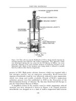
changed colour in relation to depth. Only the invention of the echo sounder
in the 1920s, which timed the return of a noise from the bottom, brought
real improvement, and the great advantage that it could maintain a
continuous record.
Measuring the speed of a ship through the water was, from the mid-sixteenth
century, done by the hand log, by timing the running out of a regularly knotted
rope for a fixed period, the number of knots passing being termed the speed, hence
the ‘knot’ being the unit of speed at sea. It was also possible to use the Dutchman’s
log, that is, to time an object passing down the ship’s side between bow and stern.
Both methods were obviously approximate, and contributed to the general
inexactitude of navigation. In 1802, Massey produced a speed-recording machine
similar in principle to his depth recorder, driven by a rotating float towed astern,
and this system is still in use in the modern patent log. More recent methods
include a recorder driven by a small propeller attached to the hull, while the
Chernikeef type uses water pressure on a diaphragm in the hull.
Another of the old inexactitudes was compass error, which was little
understood until the work of Matthew Flinders early in the nineteenth century
on the magnetism of a ship’s hull as well as on deviation and variation. An
Admiralty Committee in the 1830s extended this work, and also designed a
compass card which was steadier than previous ones. The introduction of iron
ships obviously accentuated the effect of hulls upon a compass and necessitated
more precautions. Lord Kelvin devised another card in the 1870s, and
generally speaking, with regular correction and swinging of the ship, the
magnetic compass was reliable and needed little attention. Early in the
twentieth century, however, it was found that a gyroscope, left spinning freely,
adopts a constant axis and could serve as the basis for a compass, which would
give ‘true’ readings direct, while it also could have repeaters driven off the
master, and consequently the gyro compass achieved considerable popularity.
Since 1945 navigation has changed radically. The wartime refinement of
radar and the Decca navigator carried further the use of radio techniques
begun before the war with directional position finding. Radar gives the
navigator a view of the sea and land in his vicinity, together with the shipping,
and can provide accurate bearings and distances, with allowance too in many
sets for one’s own ship’s movements, though its use has also produced
problems of interpretation. The Decca navigator uses the former DF principle
PART THREE: TRANSPORT
546
of two or three directional bearings from shore stations, but these are
continuously available, and can be plotted direct on to special charts to give an
accurate position at a moment’s notice. Both these developments are concerned
principally with waters near land—though radar can be used anywhere—but the
methods of inertial and satellite navigation introduced largely for nuclear
submarines in the 1960s, provide ships so fitted with instantaneous and reliable
positions when far from land.
CHARTS AND SAILING DIRECTIONS
The earliest charts and their associated texts which give detailed advice to the
mariner, sailing directions, are known from classical times, but the earliest
surviving ‘sea-maps’ are the so-called portolani, drawn with ink on skins, in
mediaeval times. The methods of producing these maps are not certainly
known, and, although at a glance many show recognizable outlines of coasts,
they are inadequate in detail. There were errors in longitude, while the idea of
projection was not understood, nor was the size of the earth known, so that all
charts well into the eighteenth century—and even after—embodied errors. In the
late sixteenth century Dutch cartographers led, producing printed engraved
charts which had wide usage; they were generally known as Waggoners, a
corruption of the name of Lucas Waghenaer who first produced them in 1584.
The secrecy which many countries maintained with relation to their
possessions was to some extent dispelled by these charts, but they were copied
extensively and for too long after better work was available. In England,
Captain Greenvile Collins produced some more detailed charts of many
localities in the 1680s which embodied improved methods of survey. While the
Dutch charts certainly included some sailing directions, most prudent mariners
also kept their own remarks about the pilotage of ports they had visited.
Commercially produced charts held the field for many years. The French
navy set up a Hydrographic Office in 1723, the English East India Company
appointed Alexander Dalrymple as its hydrographer in 1779, but the British
Admiralty did not follow these enlightened leads until 1795, although naval
officers had been surveying regularly long before. Dalrymple’s appointment to
the Admiralty post was not followed by an extensive output of charts for
various reasons, and it was not until 1810 onwards that the Admiralty chart
began to establish its reputation. However, from 1815 onwards, the Royal
Navy embarked upon a serious effort to chart much of the world, using recent
scientific progress to raise the standard very considerably. The long and
arduous work of officers such as Smyth, Fitzroy, Owen, King and Denham,
together with efficient production and distribution, made these charts more
widely available. Meanwhile, Horsbrugh, Dalrymple’s successor, produced a
valuable series of sailing directions for the eastern seas. From the 1860s,
PORTS AND SHIPPING
547
however, the Admiralty also began its own series of sailing directions or Pilots
as they are commonly called, and the resurvey, and revision of both charts and
pilots was placed on a regular basis.
The British example was followed by many other countries, and for many
years most nations have undertaken their own survey work. The work of the
surveyors has been much assisted by subsequent developments of new
techniques and of instruments such as radar and echo sounders and even aerial
survey. Special charts have been found necessary for use with navigational
systems such as Decca, and standardized formats have been adopted.
PORTS AND HARBOURS
The importance of good harbours to economic development needs little
emphasis. Not only must ships be able to load and discharge in safety, but for
centuries they also needed shelter on their voyages or safe anchorages where
they could wait for winds. Until relatively recently, however, man depended on
the gifts of geography for these important elements of his society.
The earliest craft could readily be beached. When ships became larger, and
this was no longer feasible, sheltered places had to be sought where ships could
lie peacefully alongside the shore or bank to load or unload. Such sites were
mostly on rivers, often, indeed, some way up and not uncommonly at the
lowest bridge. Structures in timber, and as early as Roman times in stone, brick
or concrete, might be built as quays over which cargo could be worked. Quite
extensive works were created in harbours such as Ostia, but much of this
knowledge was lost in the Dark Ages, and harbour works remained
rudimentary for many centuries. In many cases ships had to lie in the river and
load or unload from barges. In such ports, the tide was of much assistance to
ships in working up and down the river. London, Antwerp, Rotterdam and
Hamburg may be given as examples of this type of port, and countless others
may be found. Away from the sandy and low-lying shores of northern Europe,
however, reliance was usually placed upon a natural harbour in a bay or arm
of the sea, where a point sheltered from wind and sea could be found and the
necessary works built. For naval purposes, where less cargo work was done,
such harbours were especially popular, as access was easier than with a river.
Portsmouth, Brest and Toulon typify such places, while Venice and Marseilles
are more commercially oriented examples. Beach cargo working, for coasters,
remained in use until the early twentieth century. For shelter during a voyage,
or as a safe place in which to await fair winds, the small merchant ship of the
sailing era might lie in the lee of an island (the Texel off the coast of Holland,
for example) or headland; offshore sandbanks often enclosed sheltered
anchorages, such as the Downs or Yarmouth Roads off the east coast of
England.
PART THREE: TRANSPORT
548
Occasional efforts to build small breakwaters against the full force of the sea
usually ended, sooner or later, in failure, with the notable exception of the mole
at Genoa in north-west Italy: the Molo Nuovo, built in 1643 survives today.
Only during the eighteenth century did engineers develop the ability both to
build and to maintain structures against the battering of the sea—Plymouth
Breakwater, Whitehaven, Ramsgate and Kingstown Harbours, for example, and
these provided amply for shelter as well as improved port facilities. The great
increase in trade beginning in the mid-eighteenth century began to make existing
ports congested, while the slow increase in the size of ships became much more
marked in the first half of the nineteenth century, and rendered the old practice
of lying on the bottom at low tide more and more undesirable. Thus efforts were
directed towards the provision of wet docks, in which ships could lie quietly in
impounded water behind locks and where cargo could be better protected and
stored. A few such docks already existed, such as the Howland Dock on the
Thames, and some in the naval dockyards and at Liverpool, but from 1800
onwards many more were built, generally by companies set up for the purpose
or by municipal authorities, and dock or harbouur management entered a new
era far removed from the small-scale efforts of the past. In ports where the tide
was less of a problem, similar improvements were nevertheless made to provide
open docks with storage and working areas behind the quays. All these works
required heavy excavation and building of robust walls, and thus a high level of
engineering skill and organization.
The advances in port engineering and organization were timely, for the
radical changes in ship design, size and purpose throughout the nineteenth
century were to set port authorities a hard task to keep abreast. Longer, wider
and deeper locks were needed, and the docks to which they led had equally to
be enlarged, while the coming of railways required the provision of additional
facilities. Steamships, for economic reasons, had to work their cargo far more
quickly than in the past, so that improved equipment and methods were needed.
To the former warehouses close to the quay were added transit sheds to organize
and collect the cargo before loading or after discharge, large storage areas for
bulk cargoes such as timber were necessary, while cranes, steam at first and then
hydraulic and electric, together with grabs for coal and suction elevators for
grain, had to be provided, as well as refrigerated warehouses for meat and later
fruit, and tanks for various liquids. The scale of these requirements also
increased as individual ships carried more cargo. Thus all ports, to keep up to
date, expanded on to new sites; many, of course, dropped out.
An era of specialization followed. Many new ports, or greatly expanded ports,
were built to meet special needs—railway companies for packet ports or coal
shipment ports, mining companies to ship their products—while in some parts of
the world, such as India or Africa, completely new ports could be built for areas
hitherto ill-served by nature, examples of which are Madras, Port Harcourt and
Mombasa (Kilindini). Even in the late Victorian era, passenger traffic was quite
PORTS AND SHIPPING
549
ill-served, tenders often having to be used at such important places as London
and Liverpool. As the number of passengers in one vessel increased with the size
of ships, improvement was needed, and preferably outside the dock so that the
ships could leave without reference to tide. Floating landing stages were therefore
provided, with railway station and road approach, waiting rooms, customs
premises and space for circulation. In more recent years, these quays and other
berths have also needed ramps to allow cars and lorries to drive on and off ro-ro
ships, with parking areas and buildings to match.
Perhaps the first of the specialized cargoes to require separate treatment was
oil, which, owing to the risks of fire, was always dealt with at special facilities,
usually long jetties with the refinery at the shore end well away from other
habitation. This tendency has spread with the increasing use of very large bulk
carriers for other cargoes. Coal, iron ore, grain and sugar are now received, as
many have long been shipped from special jetties, often adjacent to the works
which will use the cargo. The jetties are fitted with modern unloading gear-—
grabs, cranes and conveyor systems—and are sometimes of considerable length
to reach deep water. Owing to their often exposed positions and the size of the
ships using them, the construction of these jetties presents many problems.
While containers, the other modern cargo system, are usually handled over
quays in less remote situations, they need very large special cranes and much
stacking ground, as well as a deep-water berth.
Cargo handling
The handling of cargo from shore to ship and then again from ship to shore,
sometimes with further intermediate handlings such as to a lighter, was always
recognized as unsatisfactory owing to its liability to breakage and pilfering, but
only for some bulk cargoes was it possible to avoid it. Commodities such as
coal or stone could be tipped on board, and, after the introduction of the grab
crane, lifted out, while grain and other cargoes of similar characteristics could
be handled via pipes and suction pumps. Smaller but more valuable and fragile
loads could only be barrowed on the quay, then lifted in small batches by the
ship’s gear, in sailing days often by blocks and tackles from the yards, later by
derricks rigged on the masts, and then by dock cranes, all using slings and
nets. Weights were limited to a tonne or so, although this figure rose as
derricks or cranes achieved greater capacity. Beyond this weight, special heavy
cranes had to be obtained. By the 1950s, however, both cranes and derricks
could handle up to 5 tonnes, and many ships had also a heavy derrick capable
of lifting, in some cases, 80 or 100 tonnes, while port authorities also had
floating cranes available of even greater capacity.
Efforts to avoid handling go back many years, and took two forms, the
container and the roll on, roll off vessel. The ro-ro originated with the train
PART THREE: TRANSPORT
550
ferry: railway wagons could be shunted on to a special vessel and off at the
other side, using ramps or lifts to overcome tidal variations. The first such
ferry was across the River Forth in 1849, and it was followed by others,
especially in Denmark, while rather similar vessels were introduced for road
traffic across rivers, all very short crossings. Longer distance train ferries with
seagoing vessels began with the Great Belt crossing in Denmark in 1883, and
this was followed by others across the Baltic, in the Great Lakes area and
between Japanese islands, and elsewhere.
By 1939 the need for similar vessels to convey motorcars was recognized
and a few were in service, often on the same routes. During the war, the
situation was altered by the construction of large numbers of landing ships and
craft for what in essence was a similar purpose, though these relied on bow
ramps or doors rather than the stern loading usual in the existing vessels. After
the war, converted landing ships or craft were utilized to open new routes, and
further new vessels were built for fast cross-channel routes. It was not until the
1960s that a fresh wave of development began based on the conveyance of
lorries. New ships were needed with greater headroom and more deck space,
as well as loading facilities at both ends. A vast reorientation of trade towards
short sea crossings resulted, as well as the decline of many ports. In the late
1970s many deep sea vessels were being provided with ro-ro facilities.
The second radical development was the container. This also began with the
railways, which, after using small containers to hasten the transfer of baggage
from express to cross-channel steamer before 1914, introduced larger ones
between the wars to provide a door-to-door service in reply to the competition of
road hauliers. These containers were also increasingly used for cargo to Ireland.
In the 1950s, a new type of container was developed in America of rectangular
shape, allowing them to be easily stacked and to fit closely into suitably fitted
ships, and also to be quickly coupled and uncoupled to the crane which
transferred them between ship and shore, often direct to lorry or train. These
ISO (International Standards Organization) containers have revolutionized the
deep sea cargo trade as ro-ro has short sea crossings. Very large and fast ships
can carry several hundred such containers, and are able to do the work of
several older ships, so much so that the former shipping companies have been
compelled to form consortiums to operate the relatively few vessels needed.
Other new methods have not made so much impact. Lash and Bacat (Barge
Aboard CATamaran) ships are variations on the idea of loading a barge inland
and taking it in a seagoing vessel overseas to be distributed by waterway.
Dredgers
One of the most important aspects of maintaining a port is to keep a constant
depth of water. In areas of large tides, silting can be a serious problem,
PORTS AND SHIPPING
551
sandbanks can change very considerably and suddenly, and an increase in the
size of ships may require the channel to be deepened. For all these purposes,
various types of dredger have evolved. In the seventeenth and eighteenth
centuries, ballast was dug from river bottoms by a spade-like arrangement and
lifted to the surface, and this could be used for dredging if necessary. Such an
arrangement could be adapted to steam power, and then evolved into a chain
of buckets on a strong rigid frame, the spoil being emptied into chutes and
thence into a barge, usually a hopper barge, which could convey it well out to
sea and deposit it through bottom doors. Bucket dredgers of this type were the
mainstay of the dredging plant of a port. For quaysides and areas which a
bucket dredger could not work, a vessel, usually itself a hopper, fitted with
grab cranes was used. Suction dredgers were also employed, drawing up silt
through a pipe trailing on the bottom. In recent years, the efficiency of this
type has greatly improved, and they are now generally used in place of the
other types. Other machines such as rockbreakers and piledrivers are also
found, usually in harbour construction, while the suction principle is also
widely used to obtain gravel and sand for non-nautical purposes.
SHIPBUILDING AND DOCKYARDS
Shipbuilding in the days of timber ships was a more opportunistic business than
it subsequently became with iron and steel. Until the end of wooden
shipbuilding, it was a usual practice to build small vessels up to 30m (100ft) long
or thereabouts on a convenient site where the ground sloped down to a river,
offering a suitable site for the building ways on a firm foundation. Here, using
local timber as often as not, the keel could be laid, the frames erected and the
hull planked employing only very simple lifting appliances, and with timber
scaffolding round the hull, reached by ramps, to allow the shipwrights to work
above ground. The hull would be held upright by cradles at various points
standing on the ways, and wedged by shores. These would be removed shortly
before launch, when the ways would be greased, and the hull on the cradles
would slowly slide down to the water. Nearby would be saw pits and perhaps
sheds for shaping and preparing the timber, with a steaming kiln to bend it. If no
more orders came, the site could be abandoned and revert to nature.
Obviously there were also many shipyards which were well-established
businesses in important ports, but the essentials were the same, with associated
activities nearby, such are ropewalks, rigger’s shops, mastmakers and
blacksmiths (for much iron was used). There would also be dry docks, in
which ships could be either built or more often, repaired. Such a dock would
be excavated in the river bank, lined with timber piles and provided with
timber mitre gates closing to form a ‘V’ against the river outside. The ship
would be brought in at high tide, and carefully placed with its keel on a row of