Environmental Technologies Part 10 doc
Bạn đang xem bản rút gọn của tài liệu. Xem và tải ngay bản đầy đủ của tài liệu tại đây (844.18 KB, 20 trang )
Improving the Grapevine Technology by Optimising the Utilisation of the
Environmenthal Resources in the Murfatlar Vineyard 173
An optimum solution is to choose the less water consumer system, like drip irrigation.
The efficiency of utilizing water in the case of the sprinkle irrigation system is 50%
compared to the 85-90% of the drip irrigation (Ranca, 2005). Once with the local application
of the water in reduced quantities we can concomitantly apply the fertilization with soluble
fertilizers.
The description of the drip irrigation system existing on the pilot plot
In this step the system serves a single plantation, the Columna one, but allows for the
ulterior linkage of other plots. The bringing of water is realized through a PEHD 80D 50mm
conduct on the distance of 230 m, fueled from a common underground network of irrigation
water supply.
The first filtering is done with a main sand filter that assures a 230 mc/h debit and the
second filtering is done with a small plastic filter having a filtrating surface of 527 cm
2
,
having a debit of 28.8 mc/h. The filtering is preview with two manometers on entrance and
exit and evacuating cock.
The fertilization is done through an injector integrated in a circuit with a cock access that
assured a medium debit on the injector of 50l /min ( 3 mc/hour) of fertilized solution
injected in the irrigation water.
Distribution is done with tubes PEHD D50 mm respectively 40 mm for the distribution
antenna water on the plant rows (figures 2 and 3). After the technological probes and the
determining of the functional parameters of the installation will have introduce an
automatic programming system.
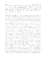
Fig. 2. Dirip irrigation distribution on the plants row in the Columna experimental plot
The watering system is previewed with plastic tubes with double incorporated drippers
situated at 60 cm from the other on the tubes length. Each dripper assures a 3 l/h debit at a
supplied water pressure of between 0.5 and 2 atmospheres, having from the construction a
pressure regulator
The functional parameters of the installation are: maximum debit assured: 34 mc/h,
maximum watering intensity: 26 mc/h/ha. A standard watering of 200 mc/ha can be done
174 ENVIRONMENTAL TECHNOLOGIES: New Developments
in 8-10 hours on normal functioning parameters. From this distribution center the water can
be supplied to other parcels, alternatively, with the condition that it must not surpass the
distance from the station as to not lose pressure.
The benefit of implementing drip irrigation system in vineyards
There are multiple direct and indirect advantages in using drip irrigation system on the
vineyards located in dry or half-dry areas.
The direct advantages are:
¾ The water quantity is reduced mainly in the areas with a continental semiarid
climate with lack of water resources
¾ Need of labor force is lowed
¾ Small and controlled fertilizers can be applied (fertigation) increasing the efficiency
of these and reducing pollution risks
¾ The intervention of the soil level was diminished, being protected the chemical and
physical soil proprieties
¾ Slope areas can be cultivated without the danger of washing of fertile level of soil
¾ The risk of phreatic water contamination with fertilizers is extremely reduced.
Fig. 3. The watering surface in drip irrigation system
Between the indirect advantages are:
¾ Unfavourish the weeds growth, the interval between plants is dry
¾ The cryptogrammic diseases risk is lower and the costs of treatments is diminished
¾ There is the possibility for underground irrigation by using herbicides in this
system
Improving the Grapevine Technology by Optimising the Utilisation of the
Environmenthal Resources in the Murfatlar Vineyard 175
¾ This system permits applying of different breeding technologies, which lead to
increase the grapes quality (table 4).
The wine quality was studied in comparison with a witness obtained on a classical breeding
technology.
The Columna wine has a constant quality on the experimental period assured by the new
technology: water supply on necessary time and of appropriate quantity, a rational
fertilization, preserving a good status health of plant, respectively grapes. In opposition the
wines obtained on a witness Columna plot has hard influences due to the lack of water at
the principal developing moments of plants (flourishing, shoots growing, berry forming)
and of the main physiological processes (photosynthesis rate, transpiration, stomata
conductance). So, the witness vines are in all this years (exception 2006 year), below the
quality of witnes obtained by the integrated technology (figure 4).
Un-irrigated plot Sprinkler irrigation Drip irrigation
Tones/
ha
Sugar
g/l
Acidit.g/l
H
2
SO
4
Tones
/ha
Sugar
g/l
Acidit.
g/l
H
2
SO
4
Tones
/ha
Sugar
g/l
Acidit.
g/l
H
2
SO
4
6,4 183,6 4,1 8,2 181,6 5,2 8,0 190,08 4,8
Table 4. Characterisation of harvest - Columna – average data 2001-2006
1,9
1,75
1,2
2,6
2,7
1,6
18,4
19 19
17,5
18,5
19
0
5
10
15
20
25
2001 2002 2003 2004 2005 2006
g/L, % , note (0-20)
0
0,5
1
1,5
2
2,5
3
g/L sugar
Total tartaric acidity g/L Alcohol vol%
Glycerol g/L Sugar g/L
Unreduced extract (g/L) Testing score (0-20)
Fig. 4. The oenological potential of the wines obtained from Columna variety
5. Conclusions
The yearly climatic condition represented mainly by thermal, lightening and hydro
parameters specific for the vineyard biotope are directly related with growing and
developing rate of plants, changing the active period of the these influencing the
achievement of a constant and qualitative harvest (Jones, 2005, Stock, 2005).
176 ENVIRONMENTAL TECHNOLOGIES: New Developments
The improved technology applied in the Columna plantation at Murfatlar proves to be not
only ecologic, diminishing the number of interventions, putting the accent on a integrate
scheme of the control of the health plants but also is economically profitable, the total
annual costs being with 15-20% smaller.
Drip irrigation system is usefull mostly in the spring and early summer months for to
supply the water needs of the vine plants in the intensive growth processes florish, berry
formation and growing).
6. References
Baicu T., Savescu A. – Sisteme de combatere integrata a bolilor si daunatorilor pe culturi. Ed.
Ceres, 1986.
Baicu T. – Principles of intedrated pest and disease management. Ed. Ceres, Bucuresti, 1996.
Condei G., Ciolacu, M., et.all. – L’approche ecologique du systeme entegre d’entretien du sol
en plantations viticoles intensives. III Symp. intern. sur la non-culture de la vigne et les
autres techniques d’entretien des dols viticoles, Montpellier, 1991, 289-296.
Cotea V, Cotea V. – Viticultura, ampelografie si oenologie. Ed. Did. si Ped. Bucuresti, 1996.
Davidescu D., Davidescu V. – Agricultura biologica – o varianta pentru exploatatiile mici si
mijlocii. Ed. Ceres, 1994.
Dejeu L., Petrescu C., Chira A. – Horticultura si protectia mediului, Ed. Didactiac si Pedagogica
Bucuresti, 1997.
Filip I. – Realizari ale combaterii moliei strugurilor in acord cu natura. Combaterea integrata a
buruienilor, p/ 270-277, Constanta, 1994.
Jones G. V., With M. A., Cooper O.R., Storchmann K., 2005 – Climate change and global
wine quality. Climatic Change 73, 319-343.
Olteanu I. si colab. – Influence of the integrated technological system under ecological
control on some physiological and biochemical processes with impact on the
viticultura yield. Analele Univ. Bucuresti, 2000.
Ranca A. – Studii preliminare in modelarea dezvoltarii moliei strugurilor la Murfatlar,
Analele ICVV, vol. XVI, 1998.
Ranca A. -
Key concerning vine breeding in the dryness conditions at the Murfatlar
vineyard, Analele Univ. Ovidius Constanta Seria Geografie Vol. II, Univ. Ovidius
Press., 2005
Stock M., Gherstengarbe F. W., Karstschall T., Werner P. C., 2005 – Reliability of
ClimateChange Impact Assessments for Viticulture. Acta Horticulture, 689, ISHS, 29-
39.
Tardea C, Dejeu L., 1995, Viticultura, Ed. Didactica si Pedagogica Bucuresti, 120-126.
XXX, Production integree. Bull. OILB, 16, p.41-61, 1993.
XXX, Bull. IOBC 23, 2000
12
Integrated Sustainable Fisheries Management
for Pearl Mullet of Lake Van, Turkey
Mustafa SARI
Fisheries Department of Agriculture Faculty of the Yuzuncu Yil University
Turkey
1. Introduction
The pearl mullet is the sole endemic fish species that can survive in the salty and alkaline
waters of Lake Van. Covering an area of 3712 km
2
, with mean depth of 171 m, maximum
depth of 451 m, and 1648 m above sea level, this is Turkey’s largest lake. Its waters are
extremely alkaline and salty. Due to the nature of these waters, it is characterized as a
“soda lake”. Researchers have reported a pH level of approximately 9.8, with saltiness at
0.19% (Kempe et al., 1978). The lake’s biological diversity is significantly different from
both fresh and salt waters. Its phytoplankton resources consist of 103 species belonging to
the Diatome, Bacteriophyta, Cynophyta, Chlorophyta, Flagellate and Phaeophyta groups, and its
zooplankton resources include 36 species from the Rotatoria, Cladocera and Copepod groups
(Selcuk 1992). The pearl mullet (Chalcalburnus tarichi, Pallas 1811), a species belonging to
the Cyprinidae family, is the only fish that can survive in Lake Van. The pearl mullet is a
migrating species. Although it generally lives in the lake, it immigrates to the surrounding
freshwater rivers for reproduction purposes and returns to Lake Van after the
reproduction period.
The earliest available information on the fishery practices related to the pearl mullet comes
from travelers that visited the Lake Van region. Among them, Evliya Celebi (17
th
century)
provides the most detailed account. Having arrived to Van with a general, Melik Ahmet
Pasha, Celebi speaks of the lake as the “Van Sea”, stating that a certain species of fish exist in
these waters that migrate annually to the Bendi Mahi River creek for a month as a flock. He
goes on to explain that the fish are captured on their way back to the lake by the provincial
treasurer, salted and then taken to the Iran, Nagorno Karabakh, and Azerbaijan area to be
sold. He says 900 loads of silver coins are thus collected for the treasury each year and this
income is then distributed among the soldiers serving in the fortress around the lake (E.
Celebi, 17
th
Century). The first detailed study on the biology of the pearl mullet was carried
out by Akgul (1980); further research was conducted by Danulat&Selcuk (1992) and Danulat
& Kempe (1992) revealing new parameters about some physiological and biological
characteristics not articulated in the previous study. Other studies on the pearl mullet
include: Arabaci’s (1995) research on physiological changes that take place during
reproductive migration; Cetinkaya et al’s (1995) on some selectivity characteristics of nets
used for pearl mullet fishing; Sari’s (1997a) research which presents the basics of current
fishery management practices and proposes an alternative model based on estimated pearl
mullet stock quantities; Sari’s study (1997b) on mesh selectivity for pearl mullet fishery; Sari
178 ENVIRONMENTAL TECHNOLOGIES: New Developments
and Tokac’s research (1997) on the technical features of Lake Van fishing boats; Sari & Ipek’s
study (1997) specifying new fishing areas around Lake Van, drawing on satellite imageries;
and Sari & Tokac’s research (2000) about the productivity of nets used for fishing the pearl
mullet.
As of 1997, technological approaches have prevailed in fishery management at Lake Van.
With the establishment of a center at the Yuzuncu Yil University focusing specifically on this
field, these studies have acquired an institutional identity (Sari 2000a). Sari (2000b) has
declared that new fishing grounds have been successfully determined with the aid of the
remote sensing and geographic information system. Using the daily AVHRR satellite images
taken from the NOAA HRPT ground station situated at the remote sensing center to
determine the surface temperature map (SST), in conjunction with depth and flow data, this
study has verified that the pearl mullet’s distribution area can be successfully established.
The effects of these applications, which will ease the transition from the erroneously
administered spawning period fishing practices to professional fishing, have been clarified
in detail by Sari (2001).
In the event of a failure to prevent spawning period fishing, the new technology will be an
added fishery pressure on the pearl mullet population; in light of this possibility, the need
for cooperation among relevant public authorities, and local, national, and international
non-governmental organizations is clearly an imperative. This paper is a detailed
examination of the transition process to sustainable fishery of the pearl mullet, the role of
relevant governmental and non-governmental bodies, security forces and universities
within this process.
2. The Biology of the Pearl Mullet (Chalcalburnus tarichi)
A member of the Carp family (Cyprinidae), the pearl mullet is a fish species that only
inhabits the Lake Van Basin. Generally of bright-silver color, its back is grayish green,
and the abdominal region is silver (Figure 1). Its body is covered with small scales, and
its eyes are large (Kuru 1987, Geldiay & Balik 1988). On the average, it measures around
19.5 cm in length, and has an average weight of approximately 80 g. It feeds on phyto
and zooplanktons. Its average life span is around 7 years, and the fish reaches
reproductive maturity at 3 years old. The reproduction period, at which time the fish
immigrate to freshwater rivers in flocks, starts in early April and lasts through the end
of July. As they cannot make the move from salty-alkaline water to freshwater directly
during the migration, the fish have a brief waiting period at the river mouths for
osmotic adaptation, both on their way to the area where they will lay their eggs and
back. As the river water temperature reaches approximately 12 °C, the pearl mullets go
into the freshwater and start to lay their eggs. Having laid the eggs in small pebbly,
sandy areas where the river tends to sprawl out and the speed of the flow is lessened,
the adults return to the lake.
Their youngsters start on the journey towards the lake within a week or two after the eggs
are hatched. The young pearl mullets wander and feed in flocks around the nutritiously rich
shore areas of the lake throughout the summer. Pearl mullets tend to disperse all over the
lake in the summer months, but avoid areas where the water is deeper than 25 m. In the
wintertime, the fish move within parts of the lake that have a maximum depth of 60 m (Sari
2001, Sari 2003).
Integrated Sustainable Fisheries Management for Pearl Mullet of Lake Van, Turkey 179
Fig. 1. Pearl Mullet (Chalcalburnus tarichi)
Fig. 2. Lake Van, important settlement areas surrounding
3. Historical Development of Pearl Mullet Fishery and its Management
The pearl mullet is captured by two different fishing methods, in two different seasons.
The fish migrates to freshwaters in order to breed between the months of April and July.
However it is not able to have direct access from the salty-alkaline waters of the lake to
the freshwater rivers. Due to its biological constitution, the fish must undergo an osmotic
adaptation process whereby it needs to wait for a certain time at the river mouths known
as “mansap”. During this “waiting” period, large flocks gather within the river mouths.
The first fishing method involves the capture of the pearl mullets, by casting beach seined
nets along the shore (beach seining), from small fishing boats as they are waiting to
continue on their reproductive migration by the river mouth. Simple traps laid along the
rivers are also employed to capture the fish during this period. Whereas 90% of the total
180 ENVIRONMENTAL TECHNOLOGIES: New Developments
pearl mullet fishing was done by this method in 1996, by 2006 around 40% was done
during the breeding period. The local population has been employing this traditional
method, capturing the fish during its migration period since ancient times (Sari 1997b,
Sari 2001).
The second method is “winter or professional fishing”, whereby the fish is captured at Lake
Van, which is its main habitat, between September and April. During this period, fishermen
use 8-16 m boats with trammelnets that mesh sizes of 20-22 mm. They start fishing at depths
of around 15-20 m in September, proceed to 50-60 m as the weather gets colder, and go back
to 20-30 m depths as spring approaches and temperatures get higher. This fishing technique
was started during the 1970s and is becoming increasingly more widespread. Nevertheless,
at present only 60% of pearl mullet fishing is being carried out in the winter months (Sari,
2006).
Until the 1960’s, pearl mullet fishing was at a minimum due to several reasons such as lack
of adequate fishing gear and equipment, and the fact that fresh fish consumption culture
had not yet developed among the local populace. In those years, the fish could not find a
place to migrate for breeding purposes, and sometimes went as far as the irrigation canals at
the surrounding fields. As a result, piles of dead fish would be seen for days on end by the
river shores in the springtime (Sari 1997b). Albeit in small amounts, all fishing activity was
carried out only during the breeding period. Since it affected a minimal part of stock
distribution within the lake, there was no need for fishing regulations. However after the
1950s, as fishing activities that took place during the breeding season took on a commercial
characteristic and as “winter or professional fishing” also started to become more prevalent
in the 1970s, pressures increased pearl mullet fishery. Following the ‘70s, it became
imperative to take some administrative measures.
The first regulatory measure related to pearl mullet fishery was the “closed season”, put into
application during the reproductive migration period even if it was for a short duration.
The dates through which fishing was prohibited during the reproduction period (closed
season), and hence the number of days when the lake was off-limits for pearl mullet fishers,
kept changing each year due to political or social conditions. However in the 1980’s, the ban
became more or less consistent and started to be applied between the dates of May 15 and
July 1
st
. In the years that followed, while there was noticeable negligence in monitoring
illegal fishing activities, it was also observed that for some reasons, the dates of the closed
season on Lake Van was haphazardly designated in different regions and the fishing ban,
devised as precautionary management strategy, was abolished in practice, even if not
legally. In the 1980s, along with the above mentioned closed season application, a limit was
also set on the mesh size to be used, both for winter and reproduction period fishing.
However, as in the case of the closed season application, since the limitations on trammel
net mesh sizes were based on the views and demands of the fishermen rather than scientific
data, this resolution too failed to be effective (Sari, 1997b). In addition, fishing during the
reproduction season was encouraged in a way, because the National Real Estate
Organization rented out the river mouths exactly at this period. Unfortunately, this practice
was continued until the lastet few years.
As a result of these management strategies, the 600-ton pearl mullet yield in 1967
showed an increasing trend, which can be seen when production is analyzed in 10-year
periods as follows: 4000 tons in 1977 (approximate increase of 700%), 10000 tons in 1987
(250% increase), 21000 tons in 1997 (200% increase) and has reached the highest yield
within the inland fish production category, with 15654 tons in 2000. Whereas the ratio
Integrated Sustainable Fisheries Management for Pearl Mullet of Lake Van, Turkey 181
of pearl mullet production to total inland fish production varied between 5-9% in the
initial years, recently this figure has gone up to 36%. This increasing trend in pearl
mullet yield has shown a decline in the last years due to overfishing. Sari (2001) has
pointed out that pearl mullet fishery has taken a course that corresponds to the “the
theory of development of uncontrolled fishing”, stating that preventive measures must
be taken.
4. Transition to Sustainable Fishery
Basically, transition to sustainable fishery of the pearl mullet means that fishing during the
reproductive period must be prevented, and should only be practiced at other times. In
essence, this is the main factor that threatens the species. This approach is prevalent in the
new management model recently developed by Sari (1997b). Effective prevention of fishing
during the reproductive period will not only result in increased revenues, but will also
require less labor and input, as well as ensure the preservation of the species. Efforts to
achieve this goal can be evaluated in three phases.
4.1 Phase 1: Defining the Existing Situation
Despite the fact that the pearl mullet presently constitutes 36% of inland fish production
in Turkey, unfortunately it is a species that has not been researched sufficiently. As a
result, studies on the general biology, stock quantity and fishery of this fish were
practically non-existent. As emphasized above, the existing studies were realized with
inadequate number of samples and within limited time restrictions. Therefore,
revealing the species’ reproductive, growth, recruitment and other characteristics had to
be the first priority. Studies conducted between the years 1993-1996 focused on the
parameters of reproduction, growth, and recruitment, thereby enabling an assessment
of stock sizes and the determination of fisheries management basis (Sari, 1997b). The
same researcher also stated that calculations related to fishing practices had revealed a
exploitation ratio (E) mean of 0.684, and reported that existing fishing practices led to
over-exploitation of the pearl mullet population, resulting in a decrease in average
length of the species, and a decline in unit and total catch yield. A series of proposals
were set forth, with a core approach that can be summarized by the following
suggestions: minimum mesh size must be 20 mm in order to prevent over-exploitation;
each boat must hold no more than 5000 m of trammel net; the dates of the fishing ban to
be applied during the species’ spawning season must be re-adjusted according to the
reproductive migration patterns of the fish; a separate unit must be established for
centralized fisheries management. At that time the sole restrictions on pearl mullet
fishing were the unmonitored “closed season” whereby the dates of the fishing ban
were determined according to the fishermen’s requests, and a limitation of minimum
mesh sizes of “16-18 mm” for the beach seine nets– an apparently random figure for
which there is no scientific basis. The “closed season” application for the lake started at
two different dates, but ended on the same date. As a result, the fishing ban was
applied between May15-July 1
st
for Van (central province) and the river mouths, rivers
or streams within the boundaries of the districts of Gevaş, Edremit and Muradiye,
whereas the ban was put into effect between the dates of May 25-July 1
st
for the district
of Erciş and within the boundaries of the province of Bitlis. Yet, the distance between
Bendi Mahi River (within the boundaries of the district of Muradiye) and Delicay or
182 ENVIRONMENTAL TECHNOLOGIES: New Developments
Haydarbey Stream (within the boundaries of the district of Erciş) consisted of 17 km
only.
As the first step for the realization of these proposals, local and federal authorities
responsible of fisheries management were informed about the situation, and were asked to
make the necessary regulatory adjustments. However, coming from a region that had not
requested any change for years on end, this appeal for change – which could easily be
considered “radical” for that period- did not immediately elicit any response. Following
lengthy disputes with local and national fisheries management agencies, a decision was
reached to unite the dates for the “closed season” application. As of the year 1996, the
fishing ban would be applied throughout the entire lake between the dates of May 10-July
1
st
, in accordance with the recommendation of the university. Thus, as the ban was put into
effect synchronously, it was also pulled forward, even if only by 5 days. On the other hand,
the subject was brought to the attention of the media, and the dangers of incorrect fishing
were explicated.
This transformation was initially met by the negative reaction of the villagers, who regarded
spawning-period fishing as their “irrefutable birthright”. The previously established
dialogue was not enough to convince them. Unfortunately, NOT A SINGLE OUTCOME
could be obtained from the measures taken to prevent fishing during the reproductive
phase. Spawning–period fishing continued full blast, and there were no controls
whatsoever. The local public agency responsible of monitoring fishery activities
recommended that the security forces should solve the problem. The security forces
responded by emphasizing that basically, this was not their responsibility.
4.2 Phase 2: Developing New Approaches and Experimenting with These Methods
An evaluation of the results (failure) of the first phase led to the conclusion that a “state-
centered” approach to fisheries management was not applicable for Lake Van, at least at
that time and under those circumstances. Therefore, non-centralist new methods were
required. As of 1996, efforts were focused in this direction. First, the correlation between
the amount of fishing and prices was clearly explained, based on observations from the
previous period. Emphasis was put on the fact that intense fishing activity during the
spawning-season was leading to decreased earnings for the fishermen. Having gained an
insight about this relationship, the fishermen were inclined to find some solutions by
themselves. These fishers were brought together with the sellers, and were encouraged to
agree on a quota system, which they, themselves would monitor. The most important
aspect of this strategy based on the quota system, was that it would bring a novel
approach to the monitoring process that was somehow never accomplished by the state
authorities, by drawing on the supply and demand balance as a brand new leverage
element, while at the same time preventing erroneous fishing practices through the active
involvement of voluntary inspectors. The fishermen and sellers, under the supervision of
lead researcher, reached a consensus on this issue and signed a page-long mutual
agreement document. The agreement stipulated that the “closed season” application
would start on June 1
st
, rather than May 10
th
of each year; the fishermen would not catch
more than 3 tons of fish daily, and the sellers would not buy below a price specified in the
document. This management strategy would be in practice for 2 years, by the end of
which, spawning-period fishers would have saved some capital. At the end of the 2-year
period, they would all join forces to support the prevention of spawning-season fishing.
Integrated Sustainable Fisheries Management for Pearl Mullet of Lake Van, Turkey 183
The official authorities would not be involved in any part of this process, except for
making the necessary adjustments in the circular (Sari, 1998). However, the local fisheries
management authority opposed this proposal on the grounds that it would lead to a “fish
massacre” in spite of the fact that they had never taken action to enforce control
mechanism. So this novel approach, the result of nearly a year’s work and built on hard-
earned trust, never came to realization. Nevertheless, many national NGOs became aware
of the issue during the preparation of this proposal. The errors of the methods used for
the capture of pearl mullets took place in the media time and again. National NGOs
declared to the relevant ministries and fishers that they would keep on pursuing this
subject. This cooperation, while perceived as a hard-to-beat union by the fishermen, also
enabled the pearl mullet to become a national issue rather than a local matter. On the
other hand, the General Directorate of Fisheries Circular Number 33/1, put into
application in the years 1999-2000 required that the above-mentioned dates stay the same,
but also stipulated a limit on mesh size and on the number of nets that can be used for
pearl mullet fishing. In effect, the circular enforces a 20 mm mesh size and does not allow
more than 5000m netting per boat. Throughout this process, the dialogue that had
established with the fishermen developed even further. Those who were convinced that
spawning-period fishing is the wrong method were brought together, and training
programs that explicated the damage caused by erroneous fishing practices were carried
out in villages where spawning-period fishing prevailed. These efforts, encouraging
spawning-period fishers to convert to winter-fishing instead, were not viewed positively
by those fishers who were already fishing during the winter season. They were uneasy
about the possibility of newcomers exploiting the few fishing grounds they had found
through years of experience, and further decreasing the already lowered yield. In order to
determine new fishing areas, a “Remote Sensing Center” was established within the
Yuzuncu Yil University structure. New fishing grounds have started to be located using
the satellite imageries obtained daily from this center.
4.2.1 Remote Sensing Applications
Remote sensing is broadly defined as collecting and interpreting information about a target
without being in physical contact with object. The term remote sensing is commonly
restricted to methods that employ electromagnetic energy (such as light, heat, and radio
waves) as the means of detecting and measuring target characteristics (Priede 1983, Sabins
1986).
Satellites of NOAA series are scientifically designed and supply two types of imaging
products. One of them is Automatic Picture Transmission (APT) and the other is High-
Resolution Picture Transmission (HRPT). Advanced Very High-Resolution Radiometer
(AVHRR) sensor produces 1.1-km resolution images, which are suitable for terrestrial,
aquatic, and climatic studies. NOAA AVHRR images have 5 channels and cover visible
and infrared range of the electromagnetic spectrum (Sari et al., 2000). In a study
conducted by Sari (2000), 12 identical fishing net was used; during the study 6 locations
became the chief focus of the investigation. Three of these locations were old, which
fishermen have been using for fishing for a long time. The other three were newly-
determined- locations being based on the maps showing water surface temperatures and
the currents in the lake. Throughout the course of the study it was determined that the
average catch obtained from old fishing locations was found between 4.8 to 22.3 kg, while
184 ENVIRONMENTAL TECHNOLOGIES: New Developments
the average catch in newly determined locations was between 15.4 and 52.3 kg. This
translates to 2 to 5 times more product in new fishing locations than old ones (Sari, 2000).
The difference between old and new locations possibly stems from the direct relation
between the distribution of pearl mullet and high water of the temperature of the lake in
the winter.
Smith & Baker (1978) determined the higher primary productivity areas using remote
sensing techniques and then tracked the locations of sardine shoals in the seas. Kemmerer &
Benigno (1973) successfully detected the locations of fish herds in the open seas using sea
surface temperature maps. On the other hand, Narayana et al., (1995) produced sea surface
temperature maps by using remote sensing techniques which are beneficial for determining
potential fishing locations
In the light of all these findings it might be inferred that temperature plays a determining
role in finding new locations for fishing through the use of NOAA AVHRR images; but it
would be misleading. Because temperature can not be considered as the single factor
determining these results. Biological characteristic of pearl mullet, the currents and
bathymetric properties of the lake are considered as the other factors causing this condition.
Simpson (1994) pointed out that the most important event of remote sensing in fishing was
the determination of potential fishing areas; and then he reported water temperature, coastal
and bathymetric borders, currents and salinity as natural factors, which affect the
distribution of fish.
When the maps charted and measured by Sari (2000) related with surface temperatures of
Lake Van are overlapped with bathymetric and current maps measured by satellite
images. When analyzing maps, temperature changes are observed to take place in
locations in which currents were much intense while currents show changes depending
on the depts of lake. In Van Bay in which bathymetric values change rapidly and
irregularly temperature changes are also observed to be higher. If such a relationship (fish
distribution, surface temperature of lake, depth and currents) can be put into expression
through a mathematical model, daily-obtained- satellite images of fish distribution could
be observed quite effectively and fishermen could be directed to much productive areas
for fishing. Sari (2000) pointed out that the algorithm compiled through the limited data
showing the relationship between surface temperature, currents, depth and distribution of
pearl mullet in Lake Van would be insufficient and that much more comprehensive
information of every season of the year should be collected in order to compose much
valid algorithm to be used every time. When primary productivity values directly
affecting fish distribution are added to this relationship, a perfect algorithm could be
formulized and put into expression in observing potential areas of fishing through
satellite data.
In this way the technical and economical aspect of fisheries management will come to the
fore and survey studies of fish lasting for years in order to determine fish distribution areas
will be conducted in a relatively shorter period of time and much effectively. The duration
for fish finding directly effecting the cost of fishing will be shortened and the expenditures
caused by the fuel floating the boats will also be reduced.
Besides this positive contributions to fisheries, remote sensing could also turn out to
be negative when it is misused in every branch of technologies. If the fishermen have
not enough professional discipline and moral conduct of their works, and have a
lack of supervision and control they will exploit the fish stocks easily determined by
Integrated Sustainable Fisheries Management for Pearl Mullet of Lake Van, Turkey 185
satellites images in a short time. For this reason, it would be of greater importance to
fill the gaps and irregularities wrought by lack of education and awareness for this
profession before this new type of fishing is introduced to communities in the
region.
4.2.2 GIS Applications
Geographic Information Systems (GIS) is a computer-based tool for mapping and
analyzing things that exist and events that happen on earth. GIS in fisheries are being
effectively used in fisheries management, in tracking of spawning grounds of some
pelagic fish, in classification of habitats according to environmental factors, in monitoring
and conservation of spawning ground of the anadrom species, in coastal and river basin
management (Sari et al., 1998).
Lake Van Fisheries Geographic Information System (LVFGIS) has been designed for
managing fisheries in an effective way and determining the technical, economical, social,
cultural and demographical aspects related with fisheries in Lake Van as well as for
compiling data in ArcView software environment. . With this study which encompassed all
the communities dealing with fisheries around the Lake Van, LVFGIS facilitated to effective
decision making and interpretations of the impacts of every kind of change in the means
and modes of this profession.
In the previous chapter, we stated that pearl mullet was the only species adopting itself to
live in Lake Van due to extreme values in the water quality in it. For this reason, in this
study of LVFGIS only the fisheries management within in the context of pearl mullet has
been investigated and information provided here could only be available for such
management. We overlapped on LANDSAT MSS images with the borders of the lake,
streams, settlements in which fisheries are carried out. Topological pinpoints pertained to
the determined settlements were setup and then two categories were composed by defining
two different times of fisheries as winter fishery and reproductive period fishery. Then the
attribute table related with the sub-branches of every category was composed and linked
with layers.
In the category of winter fishing such topics as the name of settlement dealing with winter
fishing according to years, its location, the name of cooperative, if existed, the number of
boats, the number of nets, number of fishing days, total catch, unit catch, total population of
the settlement, people working in fisheries, demographical structure of the population
dealing with fishing, mean family members and educational status of fishermen. In the
category of fishing in reproductive period, such topics as the name of the settlement dealing
with fishing according to years, their locations, number of beach seine net, the number of
fishing days, the demographical structure of fishermen, mean family members and
educational status of fishermen were investigated.
All of the data compiled through LVFGIS from 1994 on were brought together within the
context of GIS. In case of any queries concerning the access of information, decision making
and applications made by the authorities LVFGIS can be easily used. For instance, when we
want to view the entire domains of the settlement in which the number of the boats are
more than 10 it is possible to access information in seconds on the query screen; on the other
hand if we want to see the relationship between the education status of fishermen,
demographical condition and catch yield, it is possible to evaluate the results by
overlapping to different layers in seconds by this system.
186 ENVIRONMENTAL TECHNOLOGIES: New Developments
Fisheries management is a complicated and difficult task. Especially in such countries as
Turkey in which fishermen have no access to scientific data, the fishermen are quite liable
to violate the laws and rules of fishing in a way to persuade the authorities for exploiting
the fish stock in an irregular and immoral way of fishing. Such fishermen usually come to
the authorities and pledge that fishing is the only way of source of their financial and
economical well-being; they also threat the authorities that they would begin strikes and
uprisings by migrating to the city center. However the functionality of such system as
LVFGIS will never allow the ill intentions and misuse of such fishermen for the fact that
the pretexts put forward by them will quite easily be refuted through the scientific data
provided by such system since this system will monitor all the information about
fisheries, total populations, financial sources, the situation of settlement; and thus a much
more sustainable and reliable environment for fishing will be established. Fishermen are
also having the other demands such as benefiting from subventions and subsidies as well
as support from the government on the pretext that their fish were exploited by the other
fishermen of the near-by communities and a decrease in catch yield occurred, as well as
replacements which they claim to have taking place in their fish stocks. Such cases show
us that the applications of LVFGIS are of vital prominence in filling these gaps and
regulating such chaotic environment of fishermen (Sari&Guven, 2004).
4.3 Phase 3: Putting New Approaches into Practice
Even though the first and second phase of this study did not produce tangible outcomes,
they did enlighten our path to find the true solution to the problem. Having concluded by
the end of the first phase that a “state-centered” approach was not applicable, and by the
end of the second phase that relying on a “fisher-centered” strategy also did not lead to a
solution, the third phase was designed so that the NGOs would have a pivotal
responsibility in solving the issue, with the support of “public administrative bodies” and
the “fishers”. At the outset, the initiative involved touring the fishing villages at regular
intervals explaining the damages incurred through the use of improper fishing methods.
The local authorities and security forces were also visited at regular intervals and the
ecological, economical, social and cultural significance of the pearl mullet was explicated.
Brochures and posters addressing the fishing community, local authorities, security forces
and consumers were prepared and distributed. Flow of information was established with
the Ministry of Agriculture and Rural Affairs, the Ministry of Environment and Forestry
and similar federal organizations responsible of fisheries management, in order to ensure
that the subject was accurately perceived. Consequently, the gendarmerie in rural areas,
and security forces at provinces increased their monitoring activities. Whereas no action
had been taken against a single fisherman for violation of the law since 20 years, as a
direct result of improved controls, now there were times when action was taken against
more than 20 fishermen per day. Whereas 15 truckloads of fish was being sold right across
the street from the Governor’s office at the center of Van City during the “closed season”,
it was now difficult to find pearl mullets even at the smallest vendors at remote
neighborhoods. However, the spawning-season fishers felt that they had been pushed
into a corner and convinced the General Directorate of State Hydraulic Works authorities
to direct all of the water in the Bendi Mahi River into the irrigation canals for agricultural
purposes, just at the period when the fish were about to migrate to the streams and rivers
Integrated Sustainable Fisheries Management for Pearl Mullet of Lake Van, Turkey 187
to lay their eggs. Despite all efforts, no water was channeled into the streambed until the
end of the spawning season. As a result, approximately 1000 tons of fish died in the Bendi
Mahi Streambed due to dehydration and the fishers collected truckloads of fish from the
streambeds. As of the year 2001, after the issue was taken to court and a dialogue was
established with the farmers’ and irrigators’ unions, a sufficient amount of water was left
within the streambeds. An “irrigation training project” was launched in the Muradiye
area, so that the farmers would learn proper irrigation techniques and would stop using
the wrong methods. Two posters, and 4 different booklets were published for the training
project. In parallel with this venture, another project was started to help steer the
spawning-season fishers towards professional-fishing, with the support of the United
Nations Development Program Global Environment Funds Small Grants Program
(UNDP-GEF/SGP). Within the scope of this project, two separate training sets were
designed for fishing villages, and were applied throughout all of the villages in the
region. In 2002, all of the parties dealing with pearl mullet fishery management were
gathered together for the “Sustainable Fisheries Management Workshop”. The workshop
was concluded with the signing of a proclamation stating all the subjects on which all of
the participants had reached an agreement. Thus, even though there had been some
arguments, for the first time all the parties had put their signature under a single text. In
fact, this agreement was the turning point for sustainable fishing of the pearl mullet. After
this stage, every unit began to own up to their institutional responsibilities regarding
fishery management. The Preservation and Control General Directorate of the Ministry of
Agriculture and Rural Affairs, which had also participated in the shaping of this
agreement, in its circular to be effective in the 2001-2002 periods, accepted the joint
proposal made by the university and the NGOs to set the dates of the fishing ban from
April 15 to June 30. In support of the on-going scientific efforts, the Preservation and
Control General Directorate also declared in its circular that the fishing ban would
continue to be in effect for the preservation of the pearl mullet and that the same dates
(April 15-June 30) would apply for the periods covering 2002-2004 and 2004-2006. This put
an end to the legal inconsistencies that had been creating the greatest obstacle to
sustainable fisheries management. With the beginning of the fishing ban on April 15, the
long held practice of renting the river mouths for fishing purposes in the spawning-
season was effectively ended. At present, none of the river mouths around the lake are
being rented for spawning-season fishing activities. In fact, although focused specifically
on the fishery of Lake Van pearl mullets, these efforts have turned into a model for
Turkey’s inland fishery management because the problems confronting our lakes are
pretty much the same throughout the country, with minute differences. Lake Van is
unique in one aspect: the severe pollution seen around the lakes of the Mediterranean and
Agean regions is only at the beginning levels in Lake Van. Contrary to the first and
second phases, the third phase of this project has provided positive results. The over-
exploitation pressures on the pearl mullet stock have been decreased, fishing yield has
increased, and profit levels in the fishing sector have risen. The sustainability of these
outcomes depends on the dedication of relevant local institutions and organizations, and
their determination to maintain these applications. Inevitably, the need has arisen for a
local NGO that can ensure coordination between the local institutions and organizations,
own up to the heritage of previous efforts, and develop projects geared towards the
188 ENVIRONMENTAL TECHNOLOGIES: New Developments
future. The Association of Nature Observers was established in 2003 as a result of this
necessity.
5. Results of the Transition to Sustainable Fishery
The achievement of sustainable pearl mullet fishery is a subject that is of great
importance for the 14000 people around the lake who depend on it for their livelihood.
Therefore, even though the studies that have been carried out bear ecological
implications, in reality, their economic justifications are the main priority. The studies
conducted between the years 1993-2006 in three phases as summarized above, provided
excellent results, especially with the NGO-centered local fishery management strategies
adopted in the third phase; and have become a model for inland fishery management in
Turkey. 17 different training and cautionary materials were produced within the span
of this 13-year study. Clearly, the endurance of the messages resulting from studies that
deal with societal issues depends on the adequacy of educational and cautionary
documents.
The results and benefits attained through the 3-phase studies conducted with the support of
these training-cautionary materials are presented in Table 1. As can be seen in Table 1, the
number of seine nets employed for spawning period fishing has decreased by half, whereas
the number of professional-fishers has gone up by the same proportion. This indicates that
most of those who gave up spawning season fishing have started to engage in winter fishing
(Sari, 2004).
Years
Parameters
1996 2006
Number of seine nets used for spawning season fishery 92 32
Number of river mouths rented for spawning season fishery 12 0
Number of villages entirely opposed to the project (total 15
fishing villages)
9 2
Number of professional-fishers 101 165
Unit catch in professional fishing (kg/100 m/day) 2.622 8.50
Mean fork length (cm) 16.74 19.8
Number of fish per 1 kg (unit) 16-18 10-12
Total fishery revenues (USD) 3659000 7143000
Table 1. Output data obtained during transition to sustainable pearl mullet fishery
Whereas there were only 6 villages out of a total of 15, that supported the efforts to
prevent spawning-season fishing at the initial stages of the transition to sustainable
fishery management, today this number has gone up to 12 villages. Unit yield obtained
through winter fishing has increased by three-fold in comparison to 1996 figures, going
up to 8.50 kg. Decrease in size of captured fish due to over-fishing had been observed
Integrated Sustainable Fisheries Management for Pearl Mullet of Lake Van, Turkey 189
in over-exploited grounds (Pauly, 1983). Sari (1997b) has stated that this decrease in
size of captured pearl mullets is a direct result of over-exploitation and has emphasized
that the fish size will increase once over-fishing is successfully prevented. As can be
seen in Table 1, the increase in mean size of the pearl mullets is very noticeable. In the
meantime, as a result of the decline of spawning season fishery, a supply and demand
balance has started to emerge, and the revenues obtained from this fish have increased
nearly 100%. .
6. Conclusion and Suggestions for Sustainable Fishery
Although there is a rising trend in pearl mullet fishery towards sustainable fishery practices,
it must be clarified that “sustainable fishery management” has not yet been achieved.
Considering the fact that tens of species have been lost within our inland waters in the last
50 years, the achievement of this current level of protection for the pearl mullet – the only
species that can survive in the extreme ecosystem of Lake Van- definitely cannot be
underestimated. On the other hand, neither is it possible to paint a rosy picture, or to claim
that every problem has been solved.
Presently, 3 of the 15 fishing villages still insist on fishing during the spawning period. A
new project has been launched in these villages, with the support of UNDP-GEF/SGP. This
study aims to determine the reason for this difference in attitude by researching the social,
cultural, and traditional structure of villages that have abandoned spawning season fishery
practices and those that have not, while at the same time trying to change the traditional
style of consumption, which encourages fishing in the reproductive period. Also within the
context of this project is the assessment of alternative income resources for all the fishing
villages, with a special emphasis on those villages that have abandoned spawning period
fishing practices. Possible alternative income resources pinpointed during previous studies,
such as winter fishing, canned fish and salted fish production workshops, and eco-tourism,
are being studied for their adaptability to the local population’s socio-cultural and
traditional structure. Other alternative income resources generated by the local townspeople
will also be appraised.
The first priority for full transition to sustainable fishery management is the acceptance of
an NGO-centered local fishery management scheme by the fisheries management
authorities. Significant steps have been taken to this effect, demonstrated by the fact that
the dates for the fishing ban have been determined as a result of regional meetings, and
the efforts that are being made to reach decisions with the highest possible participation
in the last few years. However, the same sensitivity has not been observed in the
application of the legislature. Presently, the security forces still play a major role in
monitoring fishing activities at Lake Van. Yet legally, the security forces are only expected
to assist the local branches of the Ministry of Agriculture and Rural Affairs, which are
actually responsible of monitoring the lake. As a result, inspections are at times slackened,
depending on how the administrators of the security forces interpret their range of
responsibility. Institutionalized sustainability can only be attained if the responsible
organizations are provided with the personnel and equipment they need, and are
enforced to fully take on their monitoring responsibilities. This goal is only achievable
through the establishment of a single “local administrative unit” that will be the sole
decision-maker with regards to all fisheries management decisions for major inland
waters such as Lake Van.
190 ENVIRONMENTAL TECHNOLOGIES: New Developments
Preservation of the habitat is a basic component of sustainable fishery. Precautionary
measures that need to be taken for sustainable fishery management of the pearl mullet and
the preservation of its habitat can be listed as below:
- Establishing a local administrative unit that can achieve fishery management
single-handedly in special ecosystems like Lake Van;
- Creating alternative employment opportunities that will provide a livelihood for
the fishermen who decide to abandon spawning season fishery;
- Instigating amendments in the Fisheries Statute for the confiscation of fishing
equipment and transport vehicles in order to prevent poaching, taking the Forest
Statute as an example;
- Initiating measures to protect Lake Van, the natural habitat of the pearl mullet,
from pollution;
- Preventing the transfer of sand from riverbeds, this damages their spawning areas.
- Mandatory construction of fish passage to ease the migration of the pearl mullets
on all kinds of water structures that are to be built on rivers;
- Building boats’ shelters at suitable places for effectual management and monitoring
of fishery activities;
- Setting up processing and cold storage facilities in order to enhance the value of the
fish for marketing purposes;
- Applying ecological water distribution in order to ensure that enough water is left
in riverbeds for spawning during the reproduction period;
- Ensuring that the ecological needs of the pearl mullet are recognized as the first
priority in all the long term planning related to the lake basin.
7. References
Akgul, M. (1980). Studies on the Bio-ecology of the Pearl Mullet (Chalcalburnus tarichi, Pallas
1811) Endemic to Lake Van, Scientific and Technological Research Council od Turkey
(TÜBITAK) VII. Scientific Congress, Biology Proceedings, Aydin, pp.533-544.
Arabaci, M. (1995). Study on Some Blood Parameters of the Pearl Mullet (Chalcalburnus
tarichi, Pallas 1811), Yuzuncu Yil University Science Institute, Graduate Thesis,
Van, 52 pp.
Cetinkaya, O., Sari, M., Arabaci, M. (1995). A Preliminary Study of Fishing Yield and
Selectivity of Beach Seine Nets Used for Lake Van Pearl Mullet (Chalcalburnus
tarichi, Pallas 1811) Fishery, Ege University, Faculty of Fisheries, Journal of
Fisheries, Vol. 12(1-2): 1-13.
Danulat, E. & Kempe, S., (1992). Nitrogeneus Waste Extrection and Accumulation of Urea
and Ammonia in Chalcalburnus tarichi endemic to Lake Van, Fish. Physiol. Bioch.,
9:377-386.
Danulat, E. & Selcuk, B. (1992). Life History and Enviromental Conditions of the
Anadromous Chalcalburnus tarichi (Cyprinidae) in the Highly Alkaline Lake Van,
Eastern Anatolia,Turkey, Arch. Hidrobiol., 126(1):105-125.
Evliya Celebi (1986). The Travels of Evliya Celebi, Vol.: 3-4, (Ed., Temelkuran, T. and Aktaş,
N.) Ücdal Yayinevi, Istanbul, 766 pp.
Geldiay, R. & Balik, S. (1988). Freshwater Fishes of Turkey, Ege University Publication.
Izmir, 519p
Integrated Sustainable Fisheries Management for Pearl Mullet of Lake Van, Turkey 191
Kemmerer, A.J. & J.A. Benigno (1973). In “Symposium of Significant Results Obtained from
ERTS” Vol. I (P. Brock, Ed.). Goddard Space Flight Center, Greenbelt, Maryland.
Kempe, S, Khoo, F. & Gurleyik, Y. (1978). Hydrography of Lake Van and Its Drainage Area,
30-44 The Geology of Lake Van, Degens, E.T. and Kurtman, F. (Eds.), MTA Pub.
No:169, Ankara, 158 pp.
Kuru M. (1987). A Systematic and Zoo-Geograpgic Analysis of Pisces Endemic to Dicle-
Firat, Kura-Aras, Lake Van and Black Sea Basin Freshwaters (Unpublished thesis)
Ataturk University, Faculty of Science, Erzurum
Paluly, D. (1983). Some Simple Methods for the Assessment of Tropical Fish Stocks, FAO
Fish. Tech. Pap., No:234, Rome, 52p.
Pride, I.G. (1983). “Use of Satellites in Marine Biology, In:Experimental Biology at Sea”
(Edited by A.G. MacDonald and I.G. Priede) 3-50, Academic Press, London.
Sabins, F.F. (1986). “Remote Sensing Princibles and Interpretation”, Second Edition, W.H.
Freeman and Company, New York, 449 p.
Sari, M. (1997a). Selectivity of Nets used in Pearl Mullet Fishing (Chalcalburnus tarichi, Pallas
1811), Mediterranean Fishery Congress, April 9-11, 1997, Izmir, pp. 93-102
Sari, M. (1997b). Assessment of Stock Sizes of the Lake Van Pearl Mullet (Chalcalburnus
tarichi, Pallas 1811) and Determination of the Basics of Fisheries Management. Ege
University, Science Institute Doctorate Thesis, 150 pp., Izmir 1997
Sari, M. & A. Tokac (1997). Some Technical Features of Lake Van Fishing Boats,
Mediterranean Fishery Congress pp. 693-696, April 9-11, 1997, Izmir.
Sari, M. & S. I. Ipek (1997). A Preliminary Study on the Determination of New Fishing
Grounds Through the Use of Satellite Imary, IX National Fishery Symposium pp. 673-
682, Sept. 17-19, 1997, Eğirdir.
Sari, M. & M. Arabaci (1997). Reproduction and Fecundity in the Pearl Mullet (Chalcalburnus
tarichi, Pallas 1811) Population, Mediterranean Fishery Congress pp. 537-544, April 9-
11, 1997, Izmir.
Sari, M. (1998). Restructuring is needed for effective use of Lake Van. Deniz Postasi
Number:4, TÜDAV, Istanbul.
Sari, M., A. Tumay, A.C. Saydam (1998). Geographic Information Systems and Use in
Fisheries, First International Symposium on Fisheries and Ecology Proceeding pp 108-
114, September 2-4 1998, Trabzon.
Sari, M. & A. Tokac (2000). Comparative Study of Net yiled of Two Different Beach Seine
Nets Used in Pearl Mullet (Chalcalburnus tarichi, Pallas 1811) Fishing, Ege
University, Faculty of Fisheries, Journal of Fisheries, Vol. 17(3-4): 27-33.
Sari, M. (2000a). Yuzuncu Yil University Remote Sensing Center, Projects in Progress and
Selected Abstract of Results, Eastern Anatolian Region IV. Fishery Symposium
Proceedings pp.185-201, June 28-30, 2000, Erzurum.
Sari, M. (2000b). Identification of New Fishing Grounds by Using RS and GIS Techniques in Lake
Van, Eastern Turkey. Agroenviron 2000, 2nd International Symposium on New Technologies
for Environmental Monitoring and Agro-Applications Proceedings pp 47-56, Trabzon.
Sari, M., I. Polat, A.C. Saydam (2000). NOAA AVHRR Uydu Göruntuleri Ile Van Gölu
Yuzey Sicakliğinin Izlenmesi, 4. Doğu Anadolu Su Ürunleri Sempozyumu, 825-842
pp., 28-30 Haziran 2000, Erzurum.
Sari, M. (2001). Assessment of Stock Sizes of Lake Van Pearl Mullet and Determination of the Basics
of Fishery Management, CEKÜL Foundation, Scientific Series, 150 pp. ISBN-975-
6825-01-04, Istanbul.
192 ENVIRONMENTAL TECHNOLOGIES: New Developments
Sari, M. (2003). The Pearl Mullet of Lake Van: information and law 2003, CEKÜL and Game Wild
Life Publications, Istanbul.
Sari, M. (2004). Achieving Sustainable Productivity in the Fishery Management of the Pearl
Mullet Endemic to Lake Van Project ,Final Report, UNDP-GEF/SGP Final Report,
Ankara.
Sari, M. (2006). Threatened Fishes of the World: Chalcalburnus tarichi (Pallas 1811)
(Cyprinidae) living in the highly alkaline Lake Van, Environmental Biology of Fishes,
(Online) DOI 10.1007/s10641-006-9025-4, 79:69-70,
Smith, R. C. & K. S. Baker (1981). The bio-optical state of ocean waters and remote sensing,
Limnol. Oceanogr., 23, 247-259.
Simpson, J.J. (1994). Remote Sensing in Fisheries: A Tool for Better Management in the
Utilization of a Renewable Resource, Can. J. Fish. Aquat. Sci., 51:743-771.