Encyclopedia of geology, five volume set, volume 1 5 (encyclopedia of geology series) ( PDFDrive ) 1938
Bạn đang xem bản rút gọn của tài liệu. Xem và tải ngay bản đầy đủ của tài liệu tại đây (60.72 KB, 1 trang )
NORTH AMERICA/Atlantic Margin 95
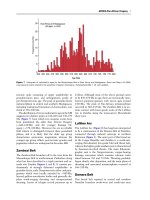
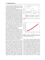
300 km between about 1200 m and 5500 m water
depth. Off Newfoundland, the slides, turbidites, and
other mass-flow bedforms resulting from the 1929
earthquake on the south-eastern Grand Banks can
be identified in water depths from about 500 m to
3000 m.
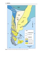
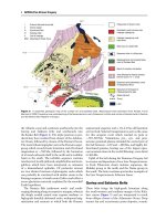
Tectonic Evolution
The North American Atlantic Continental Margin
is the product of continental rifting and seafloor
spreading (see Plate Tectonics), which began in the
Mesozoic between North America, Africa, and, eventually, Europe. Rifting is the phase of stretching and
fracturing of continental crust that culminates in seafloor spreading (drifting), which creates new oceanic
crust as the continental blocks move apart. These
tectonic processes are directly responsible for the
modern configuration of basins, platforms, magnetic
anomalies, and oceanic fracture zones along the
margin (Figure 4).
Early Triassic rifting began in an extensive interior
mountain range in the supercontinent of Pangaea (see
Pangaea) (Figure 5A). A series of rift basins formed
between what are now the Gulf of Mexico and the
Bay of Biscay. Rifting intensified in the Late Triassic
(Norian), and true seafloor spreading progressed
from the south at about 200 Ma to the north at
about 185 Ma in what is now maritime Canada.
Spreading near Newfoundland initially did not continue north of the Gibraltar transform zone at the
northern edge of the African block. The Grand
Banks were located north of the Gibraltar transform
and, although extended during this time, behaved as a
unit with Gibraltar and the European Plate.
Rifting and drifting along the entire margin are
inferred to have overlapped during the Early Jurassic.
A major basaltic extrusion event is recorded in the rift
basins at about 200 Ma (Early Jurassic). Basalt flows
are exposed throughout the Newark Supergroup. Numerous feeder dykes can be mapped in the exposed
rocks surrounding the rifts (e.g. Shelburne Dyke in
Nova Scotia, the Great Dyke in the Carolinas). These
dykes probably also exist beneath the submerged
continental margin, but are difficult to map beneath
large thicknesses of postrift sediments. Rifting ceased
during the Middle Jurassic.
The East Coast Magnetic Anomaly (ECMA;
Figure 4), marks the western edge of the oceanic
crust. The oldest oceanic crust near the ECMA was
created during the Jurassic magnetic quiet zone and,
therefore, is does not contain datable seafloor magnetic anomalies. The oldest seafloor-spreading isochron that can be identified on both sides of the
Atlantic is M25 (about 156 Ma, Late Jurassic).
During the Middle and Late Jurassic, the continents dispersed and readjusted to tectonic events that
were occurring in other parts of the fragmenting remnants of the Pangaean supercontinent. The initially
shallow and restricted ocean basins deepened and
widened as North America and Africa separated. In
the Late Jurassic, a major plate (see Plate Tectonics)
reorganization between North America and Europe
rejuvenated synrift basins that initially formed in the
Triassic on the Grand Banks of Canada (e.g. Jeanne
d’Arc Basin). This rifting ended when seafloor spreading began between the Grand Banks and Iberia during
the early Barremian (126 Ma, Early Cretaceous), initiating the final separation of Europe from North
America (Figure 5B). Another plate reorganization
in the Early Cretaceous (middle Aptian, about
110 Ma) completed the separation of North America
from Europe when the northern part of Flemish Cap
(and Orphan Knoll) separated from the Rockall
region of the north-west European margin as seafloor
spreading began in the Labrador Sea.
Alkaline basaltic magmatism, not obviously associated with breakup, created the New England
Seamounts, (see Seamounts) which extend from the
continental slope (Bear Seamount) to the foothills of
the Mid-Atlantic Ridge. The age of the seamount
chain has been difficult to establish, but it is now
generally felt to have formed episodically between
the Early Jurassic (125 Ma) and the middle Cretaceous (90–82 Ma). A younger, middle Cretaceous
age for some of the White Mountain magma series
in New Hampshire indicates that this younger
magmatic pulse may have extended inland.
The Cenozoic has been a period of stable plate
configurations, in which the Atlantic Ocean has widened and deepened. There are two exceptions to this
otherwise stable tectonic regime. First, the Labrador
spreading centre was abandoned and the Norwegian
and Arctic Oceans began opening in the Late Paleocene. This gave rise to the mid-ocean ridge configuration that persists today between Newfoundland and
Florida (Figure 5C). Second, at least two large bolides
hit the margin (see Impact Structures). One excavated
a crater 85 km wide beneath Chesapeake Bay in the
late Eocene (35 Ma; Figure 6). A second smaller
impact structure, 45 km wide, called the Montagnais
structure, was formed at about 51 Ma near the
shelf–slope break off Nova Scotia.
Passive Margin Structure
During the last 200 Ma, three major tectonic processes
have affected the structure of the North American
Atlantic Continental Margin: rifting, which broke
apart Pangaea, thinned the continental crust by