Encyclopedia of geology, five volume set, volume 1 5 (encyclopedia of geology series) ( PDFDrive ) 2269
Bạn đang xem bản rút gọn của tài liệu. Xem và tải ngay bản đầy đủ của tài liệu tại đây (202.02 KB, 1 trang )
426 REMOTE SENSING/GIS
and frequently in helping to identify appropriate
remediatory activities.
The Integrated Global Observing Strategy (IGOS)
is a strategic partnership linking research, and longterm monitoring and management with data users
and suppliers, for global environmental observations
of the atmosphere, oceans, and land. Its themes
include all the main geohazards (earthquakes, volcanoes, subsidence, and landslides) and one of its key
objectives is ‘‘to develop and integrate Earth observation data, in-situ spatial data organisation, spatiotemporal data modelling and analysis, using GIS, for
a global, integrated geohazard monitoring system’’.
Information about IGOS, its contributing partners
and its goals, can be found on its website at http://
www.igospartners.org.
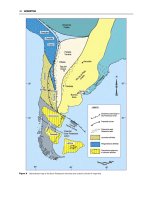
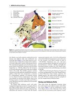
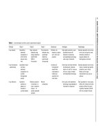
Landslides Landslide hazard assessment involves
the classification of the land surface into areas
according to the degree of potential hazard posed by
mass movements; an example of a landslide hazard
assessment map is shown in Figure 5. Many methods
and techniques have been proposed and used to quantify causative factors and GIS is commonly used to
produce maps representing the probability of occurrences, on the basis of occurrences in the past.
This ‘direct’ method of hazard assessment consists
of geomorphological mapping of past and present
landslides, and identification of factors leading to
instability. GIS is then used for classification, or zonation, to reveal sites where future failures are most
probable. The alternative ‘indirect’ method includes
two different approaches, namely the didactic or statistical (data driven) and heuristic (knowledge driven)
techniques. The didactic approach involves construction of an abstract model and proposal of hypotheses,
followed by experiments and data collection, testing of the hypotheses and finally the construction
of landslide instability rules. In the heuristic approach, landslide-influencing factors, such as slope
angle, lithology, landform, and land-use, are ranked
and weighted according to their expected significance
in causing slope instability, and the success of the
result is tested against known cases before rules are
constructed (see Sedimentary Processes: Landslides).
Vulcanology GIS contributes many tools to manage
field data (such as steam, water, and soil geochemistry), enabling patterns of output and geochemical
changes to be identified effectively, and presented
graphically. Another important role for GIS is in the
modelling and prediction of the behaviour of ejected
materials and mass movements after eruptions. Using
a Digital Elevation Model (DEM) images, and maps,
the existing topography can be analysed, enabling
paths, discharge rates, and velocities of potential
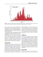
Figure 5 Map showing relative landslide hazard levels as derived from a multi criteria elimination and characterization model, of an
area of the Three Gorges region in China. The locations of the landslides, which are known to be active in this area, are indicated by
black polygons.